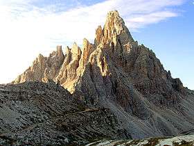
Paternkofel
| Paternkofel | |
|---|---|
 | |
| Highest point | |
| Elevation | 2,744 m (9,003 ft) |
| Prominence | 225 metres (738 ft) |
| Coordinates | 46°37′31″N 12°18′55″E / 46.62528°N 12.31528°ECoordinates: 46°37′31″N 12°18′55″E / 46.62528°N 12.31528°E |
| Geography | |
| Location | South Tyrol / Province of Belluno (both Italy) |
| Parent range | Dolomites |
| Climbing | |
| First ascent | 11 September 1882 by Franz Innerkofler |
The Paternkofel (Italian: Paterno; German: Paternkofel) is a mountain in the Dolomites on the border between South Tyrol and the Province of Belluno, Italy.
References
- Richard Goedeke: Sextener Dolomiten. (Alpine Club Guide) Bergverlag Rother, 1988. ISBN 3-7633-1255-2
External links
![]()
This article is issued from
Wikipedia.
The text is licensed under Creative Commons - Attribution - Sharealike.
Additional terms may apply for the media files.