Paso Bonilla
| Paso Bonilla | |
|---|---|
| Village | |
 | |
 Paso Bonilla Location in Uruguay | |
| Coordinates: 32°9′0″S 56°7′0″W / 32.15000°S 56.11667°WCoordinates: 32°9′0″S 56°7′0″W / 32.15000°S 56.11667°W | |
| Country |
|
| Department | Tacuarembó Department |
| Population (2011) | |
| • Total | 510 |
| Time zone | UTC -3 |
| Postal code | 45011 |
| Dial plan | +598 463 (+5 digits) |
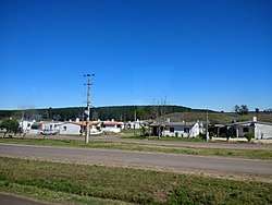
Paso Bonilla is a village or populated centre in the Tacuarembó Department of northern-central Uruguay.
Location
The village is located on the junction of Route 5 with Route 59, about 10 kilometres (6.2 mi) south of the department capital city Tacuarembó. About 1.5 kilometres (0.93 mi) north of the village is the so-called "Paso Bonilla", which coincides with the actual bridge of Route 5 over the stream Arroyo Tranqueras.
Population
In 2011 Paso Bonilla had a population of 510.[1]
| Year | Population |
|---|---|
| 1963 | 74 |
| 1975 | 368 |
| 1985 | 743 |
| 1996 | 286 |
| 2004 | 445 |
| 2011 | 510 |
Source: Instituto Nacional de Estadística de Uruguay[2]
References
- ↑ "Censos 2011 Tacuarembó (needs flash plugin)". INE. 2012. Retrieved 25 August 2012.
- ↑ "1963–1996 Statistics / P" (DOC). Instituto Nacional de Estadística de Uruguay. 2004. Retrieved 4 July 2011.
External links
Capital: Tacuarembó | ||
| Towns and villages | 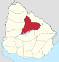 | |
| Sights | ||
This article is issued from
Wikipedia.
The text is licensed under Creative Commons - Attribution - Sharealike.
Additional terms may apply for the media files.