Parish of Buntiara
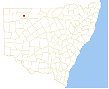
Location of the Parish

Map of Ularara County in North west New South Wales
Buntiara is a Parish of Ularara County in north west New South Wales.[1] It is between Milparinka, New South Wales and Wilcannia and west of Wanaaring.
The main economic activity of the parish is agriculture, with the Ardoo and the Salisbury Downs Station.[2] the parish is at 29°58′45″S 143°47′30″E.
History
The Parish is in the traditional lands of the Bandjigali and Karenggapa people. The Burke and Wills expedition were the first Europeans to the area.
Climate
The climate is semi-arid, featuring low rainfall, very hot summer temperatures and cool nights in winter. The parish has a Köppen climate classification of BWh (Hot desert)[3]. A minimum temperature of -3.9 oC was recorded in nearby Wanaaring in July 1997.[4]
| Wanaaring | ||||||||||||||||||||||||||||||||||||||||||||||||||||||||||||
|---|---|---|---|---|---|---|---|---|---|---|---|---|---|---|---|---|---|---|---|---|---|---|---|---|---|---|---|---|---|---|---|---|---|---|---|---|---|---|---|---|---|---|---|---|---|---|---|---|---|---|---|---|---|---|---|---|---|---|---|---|
| Climate chart (explanation) | ||||||||||||||||||||||||||||||||||||||||||||||||||||||||||||
| ||||||||||||||||||||||||||||||||||||||||||||||||||||||||||||
| ||||||||||||||||||||||||||||||||||||||||||||||||||||||||||||
References
- ↑ "Ularara". Geographical Names Register (GNR) of NSW. Geographical Names Board of New South Wales. Retrieved 11 August 2013.
- ↑ / Map of the County of Ularara, Western Division, Land Districts of Bourke (New South Wales. Department of Lands).
- ↑ Peel, M. C.; Finlayson, B. L.; McMahon, T. A. (2007). "Updated world map of the Köppen–Geiger climate classification". Hydrol. Earth Syst. Sci. 11: 1633–1644. doi:10.5194/hess-11-1633-2007. ISSN 1027-5606. (direct: Final Revised Paper)
- ↑ http://www.bom.gov.au/climate/averages/tables/cw_048079_All.shtml
This article is issued from
Wikipedia.
The text is licensed under Creative Commons - Attribution - Sharealike.
Additional terms may apply for the media files.