Parish of Allundy
Location
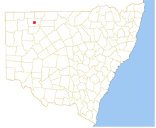
Allundy, New South Wales, located at 29°53′05″S 143°34′02″E,[1] is a parish of Ularara County in north west New South Wales, Australia.[2][3]
The main economic activity of the parish is agriculture.[4]
The Salisbury Downs Station is to the west of Allundy.
The parish is on traditional lands of the Karenggapa people.
Climate
The climate is semi-arid, featuring low rainfall, very hot summer temperatures and cool nights in winter. The parish has a Köppen climate classification of BWh (Hot desert)[5]. A minimum temperature of -3.9 oC was recorded in nearby Wanaaring in July 1997.[6]
| Wanaaring | ||||||||||||||||||||||||||||||||||||||||||||||||||||||||||||
|---|---|---|---|---|---|---|---|---|---|---|---|---|---|---|---|---|---|---|---|---|---|---|---|---|---|---|---|---|---|---|---|---|---|---|---|---|---|---|---|---|---|---|---|---|---|---|---|---|---|---|---|---|---|---|---|---|---|---|---|---|
| Climate chart (explanation) | ||||||||||||||||||||||||||||||||||||||||||||||||||||||||||||
| ||||||||||||||||||||||||||||||||||||||||||||||||||||||||||||
| ||||||||||||||||||||||||||||||||||||||||||||||||||||||||||||
References
- ↑ Map of Allundy, NSW.
- ↑ "Ularara". Geographical Names Register (GNR) of NSW. Geographical Names Board of New South Wales. Retrieved 11 August 2013.
- ↑ Map of the County of Ularara, Western Division, Land Districts of Bourke (New South Wales. Department of Lands).
- ↑ Julian Luke, Cash in goats - if you can catch them. The Land, 28 May 2013.
- ↑ Peel, M. C.; Finlayson, B. L.; McMahon, T. A. (2007). "Updated world map of the Köppen–Geiger climate classification". Hydrol. Earth Syst. Sci. 11: 1633–1644. doi:10.5194/hess-11-1633-2007. ISSN 1027-5606. (direct: Final Revised Paper)
- ↑ http://www.bom.gov.au/climate/averages/tables/cw_048079_All.shtml
This article is issued from
Wikipedia.
The text is licensed under Creative Commons - Attribution - Sharealike.
Additional terms may apply for the media files.