Paradela, Lugo
| Paradela | |||
|---|---|---|---|
| Municipality | |||
 | |||
| |||
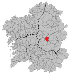 | |||
 Paradela Location in Spain | |||
| Coordinates: 42°58′N 7°57′W / 42.967°N 7.950°WCoordinates: 42°58′N 7°57′W / 42.967°N 7.950°W | |||
| Country |
| ||
| Autonomous community |
| ||
| Province | Lugo | ||
| Comarca | Sarria | ||
| Government | |||
| • Alcalde | José Manuel Mato Díaz (2007) | ||
| Area | |||
| • Total | 121.12 km2 (46.76 sq mi) | ||
| Population (2008) | |||
| • Total | 2,193 | ||
| • Density | 18/km2 (47/sq mi) | ||
| Demonym(s) | Paradelense | ||
| Time zone | UTC+1 (CET) | ||
| • Summer (DST) | UTC+2 (CEST) | ||
| Official language(s) | Galician, Spanish | ||
| Website | Official website | ||

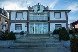
Paradela is a municipality in Lugo province in Galicia in north-west Spain. It is situated in the region of Sarria. There were 2,193 people living in Paradela as of 2008 (1,101 men and 1,092 women).[1] It is known for the connection it has with the Way of St. James. The French route of such a way, ending in Santiago de Compostela, passes through five parishes of Paradela: Ferreiros, Francos, Laxe, Cortes and Loio.[2]
Etymology
The name Paradela comes from the diminutive of the Latin word parata, which can be translated as hostal, or near the end of the journey.
Parishes
Here is a list of all parishes within Paradela, each having their own saint shown in brackets.[3]
- Aldosende (Santiago)
- Andreade (Santiago)
- Barán (San Pedro)
- Castro (San Mamede)
- Castro de Rei de Lemos (Santa María)
- As Cortes (San Salvador)
- Ferreiros (Santa María)
- Francos (Santa María)
- A Laxe (Santiago)
- Loio (San Xoán)
- Paradela (San Miguel)
- San Facundo de Ribas de Miño (San Facundo)
- San Martiño de Castro (San Martiño)
- San Vicente de Paradela (San Vicente)
- Santa Cristina de Paradela (Santa Cristina)
- Santalla de Paradela (Santalla)
- Suar (San Lourenzo)
- Vilaragunte (Santa María)
Famous people from Paradela
- Manuel Rodriguez Lopez (1934-1990) - poet, writer and translator
- Diego López Rodríguez (1981-) - football goalkeeper
Sources
- ↑ The Spanish National Institute of Statistics (INE),
- ↑ http://www.paradela.es/gl/content/o-cami%C3%B1o-de-santiago-en-paradela
- ↑ http://www.galiciaparaelmundo.com/blog/?page_id=34&recurso_id=27042
External links
This article is issued from
Wikipedia.
The text is licensed under Creative Commons - Attribution - Sharealike.
Additional terms may apply for the media files.