Paracas National Reserve
| Paracas National Reserve | |
|---|---|
| Reserva Nacional de Paracas | |
|
IUCN category VI (protected area with sustainable use of natural resources) | |
 | |
 | |
| Location | Ica, Peru |
| Nearest city | Pisco, Peru |
| Coordinates | 13°53′43.5″S 76°16′15.9″W / 13.895417°S 76.271083°WCoordinates: 13°53′43.5″S 76°16′15.9″W / 13.895417°S 76.271083°W |
| Area | 3350 km² |
| Established | September 25, 1975 |
| Governing body | SERNANP |
| Website | Reserva Nacional de Paracas (in Spanish) |
| Official name | Paracas |
| Designated | 30 March 1992 |
| Reference no. | 545[1] |
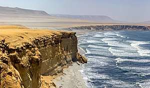
The Paracas National Reserve is located in Ica, Peru and consists of the Paracas Peninsula, coastal areas and tropical desert extending to the south slightly past Punta Caimán, a total of 335,000 hectares (3,350 km2) (217,594 hectares (2,175.94 km2) are marine waters, and 117,406 hectares (1,174.06 km2) are part of the mainland). It includes Bahía de la Independencia (Independence Bay) and miles of coastal waters. Its main purpose is to preserve the marine ecosystem and protect the historical cultural heritage related to ancient indigenous peoples, mostly of the Paracas culture.
The reserve is home to many species of wildlife, particularly birds, which are largely concentrated at the water's edge in what is called the largest concentration of birds on earth.[2] Near the entrance inside the reserve is the Muséo Sitio de Julio C. Tello. Named for the archeologist who made major discoveries about the ancient Paracas culture, it features artifacts and interpretation, as well as information about the flora and fauna of this unique region.
Protected status
Established in 1975, it is the oldest marine reserve in Peru, and it incorporates a variety of marine habitats and tropical desert. In addition to the biological areas, the reserve protects prehistoric sites of the Paracas culture and other ancient civilizations. Near the museum is the Paracas Necropolis (100 BCE - CE 300), comprising the burial sites known as the Cabezas Largas and Cerro Colorado, where Julio C. Tello found many fine grave goods buried with mummified remains of the Paracas elite.[3]
Also in the reserve is Pampa de Santo Domingo, where archeologists have dated finds of human remains to 6500 BC. Found there was a decorated quena (flute), believed to be the first musical instrument of Peru.[4]
Description
One of the main geomorphological attraction along the Paracas coast, La Catedral arch (the Cathedral) was partially destroyed during the 2007 earthquake, but it still remains one of the main attractions. The Bahia Lagunillas is bordered with red sand beaches, product of the erosion of porphyry rocks that dominate some of the hills of the Paracas Peninsula. On the Paracas Peninsula is the mysterious geoglyph called the Paracas Candelabro, which is believed to date to the Paracas culture about 200 BCE.[5]
Gallery
 La Catedral, January 2007
 La Catedral, November 2000
 A November 2000 view from within what used to be the Cathedral cave, which was destroyed in earthquake of 2007
 The red beach in Paracas National Reserve
See also
References
- ↑ "Paracas". Ramsar Sites Information Service. Retrieved 25 April 2018.
- ↑ Ashley E. Isaacson 2004.
- ↑ Pisco: "Museo de Sitio Julio C. Tello", Nile Guide, with material credited to Frommer's, 2010, accessed 4 Nov 2010
- ↑ "Paracas National Reserve", Go2Peru, 2000, accessed 4 Nov 2010
- ↑ Joseph, Frank; "The Candelabra of the Andes", The Ancient American, 2:10, no. 10, 1995, reproduced at Science Frontiers ONLINE, No. 102: Nov-Dec 1995), accessed 3 Nov 2010
Bibliography
- Ashley E. Isaacson (13 December 2004), Let's Go Peru 1st Edition, Macmillan, p. 146, ISBN 978-0-312-33566-3
External links
National Reserve of Allpahuayo Mishana: