Pančić's Peak
| Pančić's Peak | |
|---|---|
|
Панчићев врх | |
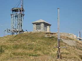 Mausoleum of Josif Pančić on Pančić's Peak | |
| Highest point | |
| Elevation | 2,017 m (6,617 ft) |
| Coordinates | 43°16′05″N 20°49′33″E / 43.268056°N 20.825833°ECoordinates: 43°16′05″N 20°49′33″E / 43.268056°N 20.825833°E |
| Geography | |
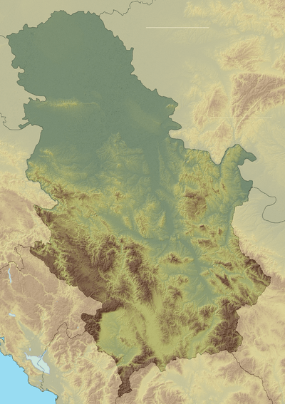 Pančić's Peak Location in Serbia (including Kosovo) | |
| Location | Brus, Serbia |
| Parent range | Kopaonik |
| Climbing | |
| Normal route | From Brzeće |
Pančić's Peak (Serbian: Панчићев врх, translit. Pančićev vrh, Albanian: Maja Pançiq[1]) is the highest point in the Kopaonik mountain range, which straddles southern Serbia and northern Kosovo.[lower-alpha 1] The peak is 2,017 m high,[2] located in the Brus municipality in Serbia.[3][4][5][6] The Serbia–Kosovo demarcation line lies some 50 m south of the summit.[7][3] Pančić's Peak is part of the Suvo Rudište mountainous plateau and natural zone[8] of the Kopaonik National Park. The Kopaonik tourist center operates cable cars to Pančić's Peak and Suvo Rudište Peak.[9][10]
The mountain peak was previously named Milan's Peak (Миланов врх, Milanov vrh) after the first king of modern Serbia, Milan Obrenović. On 7 July 1951 it was renamed after the Serbian botanist Josif Pančić, whose remains were buried at the top in a small mausoleum,[11] located next to the radio tower.[12] A memorial to Pančić was placed at the top already in 1897.[13] The site was damaged during the 1999 NATO bombing of Yugoslavia.[14][15][16] The Serbian portion of the Kopaonik (including Pančić's Peak) are part of the Kopaonik National Park, and the only road access to the peak is via the park.[7] The peak can be easily reached from the Konaci tourist complex by foot.[2]
See also
Annotations
- ↑ Kosovo is the subject of a territorial dispute between the Republic of Kosovo and the Republic of Serbia. The Republic of Kosovo unilaterally declared independence on 17 February 2008, but Serbia continues to claim it as part of its own sovereign territory. The two governments began to normalise relations in 2013, as part of the Brussels Agreement. Kosovo has received formal recognition as an independent state from 113 out of 193 United Nations member states.
References
- ↑ "Nazewnictwo Geograficzne Świata" (PDF) (in Polish). Warsaw: Komisja Standaryzacji Nazw Geograficznych poza Granicami Rzeczypospolitej Polskiej. 2009. p. 116.
Maja Pançiq [alb.]; Pančićev vrh [serb.]
- 1 2 Summit Post 2008.
- 1 2 "Katastarske parcele iz digitalnog katastarskog plana 03.03.2010". Republički geodetski zavod. ; "Initial geoportal". geoSerbia.
- ↑ "Kultura". Opština Brus.
- ↑ "O Brusu". Turizam Opštine Brus.
- ↑ "Жикина Шареница". RTS. 21 August 2011.
- 1 2 Pančićev vrh at Google Maps.
- ↑ "Suvo Rudište". Nacionalni park Kopaonik.
- ↑ "Plan naselja Suvo Rudište". Turistički centar Kopaonik.
- ↑ "Kopaonik". Ski resorts of Serbia.
- ↑ "Josif Pančić i Kopaonik" (in Serbian). Skijanje. Archived from the original on 3 January 2011.
- ↑ "TRANSVERZALA "JOSIF PANČIĆ" NA KOPAONIKU" (in Serbian). Archived from the original on 2010-08-30.
[From KT-5, one can go on Pančić's Peak 2016m, where is mausoleum of Josif Pančić, which is inside of military object and can be visited only with a previous permission issued by the Military.]
- ↑ Budislav Tatič; Božidar P. M. Ćurčić (1998). Sabrana dela Josifa Pančića: Zoološki radovi. Zavod za udžbenike i nastavna sredstva. p. 421.
- ↑ "Gađali i mauzolej" [They even bombed the mausoleum] (in Serbian). Ilustrovana Politika. Archived from the original on 8 July 2012.
- ↑ Sempervivum kopaonikense in Kopaonik gora
- ↑ House of Commons Hansard Debates for 26 Apr 1999 (pt 26), remarks of Tam Dalyell citing Kenneth Aitcheson of Rescue (British Archaeological Trust).
Sources
- Maletić, Mihailo (1968). Josif Pančić: Kopaonik i njegovo podgorje. Izdavačko odeljenje Istorijskog arhiva.
- Milićević, Jovan (1965). Srbija: Znamenitosti i lepote. Književne novine. p. 29.
- Naše Planine. 31. 1979. p. 274.
External links
| Wikimedia Commons has media related to Pančić's Peak. |
- "Pančićev Vrh". Summit Post. 12 March 2008.
- "Pančićev vrh". Google Maps.