Palo Alto Airport
| Palo Alto Airport | |||||||||||
|---|---|---|---|---|---|---|---|---|---|---|---|
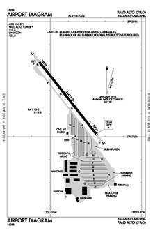 Diagram of the Palo Alto Airport (PAO) located in Palo Alto, California, USA | |||||||||||
| Summary | |||||||||||
| Airport type | Public | ||||||||||
| Operator | City of Palo Alto | ||||||||||
| Location | Palo Alto, California | ||||||||||
| Elevation AMSL | 7 ft / 2 m | ||||||||||
| Coordinates | 37°27′40″N 122°06′54″W / 37.46111°N 122.11500°WCoordinates: 37°27′40″N 122°06′54″W / 37.46111°N 122.11500°W | ||||||||||
| Runways | |||||||||||
| |||||||||||
| Statistics | |||||||||||
| |||||||||||

Palo Alto Airport (IATA: PAO, ICAO: KPAO, FAA LID: PAO) is a general aviation airport in the city of Palo Alto in Santa Clara County, California, USA, near the south end of San Francisco Bay on the western shore.[1] It is among the busiest General Aviation airports in the United States, though the #1 rank belongs to Van Nuys Airport (KVNY) [2]
Facilities
Palo Alto Airport[3] covers 102 acres (41 ha) and has one asphalt paved runway (13/31) measuring 2,443 × 70 ft. (745 × 21 m).
First time pilots should familiarize themselves with the complex SF Bay Area airspace, especially the overlying SFO Class B and the abutting SJC Class C airspace. Landing pilots should also watch out for bird and jackrabbit activity.
Facilities at this busy towered airport include a staffed terminal and multiple repair shops: Advantage Aviation (Cessna & Beechcraft Authorized Service Center), WVAS Inc. dba Aero Works (Diamond Authorized Service Center), Rossi Aircraft, and Peninsula Avionics. The airport is also home to a number of flying clubs (in order of establishment): Stanford Flying Club (est. 1930),[4] West Valley Flying Club (est. 1973),[5] Sundance Flying Club (est. 2006), and Advantage Aviation Flying Club. The airport is located within one-half mile of U.S. Route 101.
Fifteen miles of hiking and biking trails, affording multiple opportunities for birdwatching, form part of the adjacent 1,940-acre (785 ha) Palo Alto Baylands Nature Preserve.[6] The airport is also adjacent to a public golf course.[7] Dining options within a short walk include the Abundant Air Cafe,[8] and the Bay Café[9] at the golf course.
Instrument approaches
Palo Alto airport has two approaches, both to runway 31 with 460' MDA/1-mi visibility minimums:
The VOR approach is almost impossible to get from Air Traffic Control if the aircraft is GPS-equipped, because of the conflict with airline traffic in San Jose International Airport.
Area history
The original Palo Alto airport was located adjacent to Stanford stadium and built in the late 1920s .[10] Between 1934 and 1936, a new Palo Alto Airport was built at the airport's current location.[11]
In 1989 a comprehensive area history analysis was conducted by Earth Metrics, based upon review of extant aerial photographs.(Earth Metrics, 1989) The photo reconnaissance flights were flown in 1956, 1960, 1973, 1974 and 1980 by the U.S. Department of the Interior, and are archived by the U.S. Geological Survey in Menlo Park, California. Comparison of the aerial photographs indicate that no development had begun in the vicinity prior to 1956 other than the Palo Alto Airport and the Regional Water Quality Control Board Plant (terminus of Embarcadero Way). Between 1956 and 1960, no new development had taken place in the area; however, by 1973, the Harvey Gum Factory was on the subject site and structures were either completed or under construction at 1890 Embarcadero Road and 2440-2450 Embarcadero Way. Conditions were identical in the 1974 aerial photograph. In the 1980 aerial photograph, the Harvey Gum Factory is standing, and additional infill construction can be seen in the area such as the Baylands Business Park adjacent and to south of the site and the structure now located at 1860 Embarcadero Road. The Harvey Gum Factory was demolished in 1982, based upon Palo Alto Planning Department records.
In 2015 the City of Palo Alto took over operations from Santa Clara County, after a 50-year lease had ended.[12]
World War II
Note that though NAAS King City was built by an entity named "Palo Alto Airport Inc", it is not related to KPAO and located 100 miles further south.[13]
See also
References
Notes
- ↑ "Palo Alto Airport of Santa Clara County". Geographic Names Information System. United States Geological Survey. Retrieved 2009-05-04.
- ↑ http://studentpilot.com/interact/forum/showthread.php?20743-Busiest-GA-airports
- ↑ http://www.cityofpaloalto.org/gov/depts/pwd/palo_alto_airport/default.asp
- ↑ http://www.flystanford.com/
- ↑ http://www.wvfc.org/
- ↑ http://www.cityofpaloalto.org/gov/depts/csd/parks/preserves/baylands.asp
- ↑ http://www.cityofpaloalto.org/gov/depts/csd/golf/default.asp
- ↑ http://abundantair.com/
- ↑ http://www.baycaferestaurant.com/
- ↑ Landing Fields of the Pacific West | Page=56 | Date=1931
- ↑ Airfield Bulletins No2 | Page=23 | Date=1934 & 1936
- ↑ Sheyner, Gennady. "Council votes to take over Palo Alto Airport". Retrieved 2017-06-13.
- ↑ Shettle Jr., M L. United States Naval Air Stations of World War II. Schaertel Publishing Company. p. 117.
Sources

- Shaw, Frederick J. (2004). Locating Air Force Base Sites History’s Legacy. Washington, D.C.: Air Force History and Museums Program, United States Air Force.
- Manning, Thomas A. (2005). History of Air Education and Training Command, 1942–2002. Randolph AFB, Texas: Office of History and Research, Headquarters, AETC. OCLC 276858370.
Further reading
- Santa Clara County Airports Official Site: Palo Alto Airport
- Earth Metrics. Inc, "Phase One Environmental Site Assessment, 1870 Embarcadero Road, Palo Alto", Report No. 7897W0.001, June 2, 1989
- City of Palo Alto Staff Report, Palo Alto Airport Transfer from County of Santa Clara, Aug 11, 2014
External links
- City of Palo Alto, airport page
- FAA Airport Master Record for PAO (Form 5010 PDF)
- FAA Airport Diagram (PDF), effective October 11, 2018
- Palo Alto Airport Businesses
- Rich Acuff's Palo Alto Airport page
- Palo Alto Airport Association
- PAO Airport Joint Community Relations Committee, report July 11, 2005
- Santa Clara County Airports official site, KPAO removed from County operations
- Resources for this airport:
- FAA airport information for PAO
- AirNav airport information for KPAO
- ASN accident history for PAO
- FlightAware airport information and live flight tracker
- NOAA/NWS latest weather observations
- SkyVector aeronautical chart, Terminal Procedures
| Flying Training |
|  | ||||
|---|---|---|---|---|---|---|
| Technical Training |
| |||||