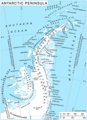
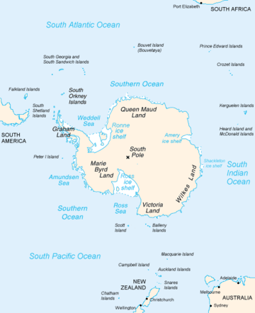
Palmer Land
Palmer Land (71°30′S 065°00′W / 71.500°S 65.000°WCoordinates: 71°30′S 065°00′W / 71.500°S 65.000°W) is the portion of the Antarctic Peninsula, Antarctica that lies south of a line joining Cape Jeremy and Cape Agassiz. This application of Palmer Land is consistent with the 1964 agreement between US-ACAN and UK-APC, in which the name Antarctic Peninsula was approved for the major peninsula of Antarctica, and the names Graham Land and Palmer Land for the northern and southern portions, respectively. The line dividing them is roughly 69 degrees south.
.
Boundaries
In its southern extreme, the Antarctic Peninsula stretches west, with Palmer Land eventually bordering Ellsworth Land along the 80° W line of longitude. Palmer Land is bounded in the south by the ice-covered Carlson Inlet, an arm of the Filchner Ice Shelf, which crosses the 80° W line. This is the base of Cetus Hill.
This feature is named after Captain Nathaniel B. Palmer; an American sealer who explored the Antarctic Peninsula area southward of Deception Island in the sloop Hero in November, 1820.[1]
Features
- Aldebaran Rock (70°50′S 66°41′W / 70.833°S 66.683°W) is a particularly conspicuous nunatak of bright red rock, located near the head of Bertram Glacier and 5 miles (8 km) northeast of Pegasus Mountains in western Palmer Land. Named by United Kingdom Antarctic Place-Names Committee after Aldebaran, an orange-colored star that is the brightest in the constellation of Taurus.
References
- ↑ Howgego, Raymond (2004). Encyclopedia of Exploration (Part 2: 1800 to 1850). Potts Point, NSW, Australia: Hordern House.
| Authority control |
|---|