Palca District, Tacna
| Palca P'allqa | |
|---|---|
| District | |
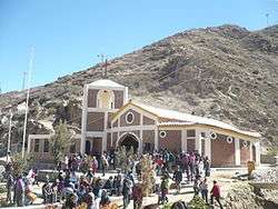 Church of Causuri near the village of Palca | |
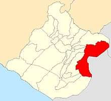 Location of Palca in the Tacna province | |
| Country |
|
| Region | Tacna |
| Province | Tacna |
| Founded | June 8, 1959 |
| Capital | Palca |
| Government | |
| • Mayor | Aureliano Gutierrez Ayca |
| Area | |
| • Total | 1,417.86 km2 (547.44 sq mi) |
| Elevation | 2,935 m (9,629 ft) |
| Population (2005 census) | |
| • Total | 1,106 |
| • Density | 0.78/km2 (2.0/sq mi) |
| Time zone | UTC-5 (PET) |
| UBIGEO | 230107 |
Palca District is one of ten districts of the province Tacna in Peru.[1]
Geography
The Barroso mountain range traverses the district. Some of the highest mountains of the district are listed below:[2]
- Awki Taypi
- Chachakumani
- Chullunkhäni
- Chunta Qullu
- Chupikiña
- Ch'alluta
- Iñuma
- Jach'a Pata
- Jach'a Qullu
- Janq'u Chawllani
- Janq'u Qalani
- Karpani
- Khuruña
- Kunturini
- Lluqu Qullu
- Piqu
- Pukata
- Pupusani
- Phaq'u Q'awa
- Qiwñani
- Qiwñuta
- Q'uli Q'ulini
- Quri Qurini
- Q'asiri
- Wanq'uni
- Wanuni
- Waña Q'awa
- Warawarani
- Wayna Pawqarani
- Wila Wilani
- Wila Qullu
- Wila Willk'i
- Wiqu
References
- ↑ (in Spanish) Instituto Nacional de Estadística e Informática. Banco de Información Distrital Archived 2008-04-23 at the Wayback Machine.. Retrieved April 11, 2008.
- ↑ escale.minedu.gob.pe - UGEL map of the Tarata Province (Tacna Region)
| |
|---|---|
| Candarave | |
| Jorge Basadre | |
| Tacna | |
| Tarata | |
This article is issued from
Wikipedia.
The text is licensed under Creative Commons - Attribution - Sharealike.
Additional terms may apply for the media files.