Paksat-1
 | |
| Mission type |
Geosynchronous satellite Communications Satellite |
|---|---|
| Operator |
SATELINDO (1996-1998) Insurers (1998-1999) Hughes (1999-2000) Boeing (2000—) Leased to: Kalitel (2000-2002) SUPARCO (2002—) |
| COSPAR ID | 1996-006A |
| SATCAT no. |
23779 |
| Spacecraft properties | |
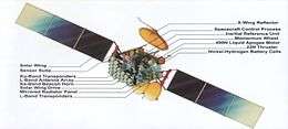
| Bus | HS-601 |
| Manufacturer | Hughes |
| Launch mass | 3,000 kilograms (6,600 lb) |
| Start of mission | |
| Launch date | 31 January 1996 |
| Rocket | Atlas IIAS |
| Launch site | Cape Canaveral LC-36B |
| Orbital parameters | |
| Reference system | Geocentric |
| Regime | Geostationary |
| Perigee | 35,493 kilometres (22,054 mi) |
| Apogee | 36,083 kilometres (22,421 mi) |
| Inclination | 0.05 degrees |
| Period | 1,436.16 minutes |
| Epoch | 2 March 1996[1] |
Paksat-1,[2] (Other former designation as Palapa C1, HGS-3 and Anatolia 1), is a geosynchronous and communications satellite built and owned by the Boeing Company, leased to the SUPARCO as PakSat. It was successfully put on orbit on 31 January 1996 as "Palapa C1" for Indonesia as its original customer. But, after the technical problems, the satellite was leased to SUPARCO at an orbital location of 38° East Longitude on December 2001. The PakSat-1 offers the C and Ku band coverage in over 75 countries across Europe, Africa, Middle East, South and Central Asia. Its customers included government organizations, TV broadcasters, telecom companies, data and broadband internet service providers.
History
PAKSAT-1 was originally known as Palapa C1. It was launched by Hughes Space and Communications Company for Indonesia. Later Indonesia declared the satellite unusable after an electric power anomaly. The insurance claims were paid and the title was transferred to Hughes Space and Communications Company.[3] HGS-3 was then acquired by Pakistan from M/s Hughes Global Services on "Full Time Leasing " and relocated to Pakistan's reserved slot at 38 degrees east.
Pakistan's Government approved the acquisition on 3 July 2002[4] and the deal with Hughes Global Services was agreed on 6 August 2002.[5] The satellite started moving to its new slot on 5 December 2002[6] and it went through a name change from Anatolia-1 to PAKSAT-1 on 18 December 2002.[7]
After a series of orbital maneuvers, the Satellite was stabilized at its final location on December 20, 2002 with 0-degree inclination. The satellite is in position at the Pakistani-licensed orbital location, 38° east longitude.
Services
The services include satellite communications in both C band and Ku band to customers in Pakistan, Africa and the Middle East. Paksat-1’s 30 C-band transponders and 4 Ku band transponders provide total range of satellite communication capabilities.
Payload characteristics
PAKSAT-1’s 30 C-band transponders and 4 Ku band transponders provide the total range of satellite communications capabilities. The satellite is in a geostationary orbit at 38° East Longitude, and carries high power payloads in both bands.
Payload characteristics of PAKSAT-1 are as below:
| C-Band Payload Characteristics | |
|---|---|
| Number of transponders | 24 in standard C-band
6 in extended C-band |
| Redundancy | All redundancy available |
| Channel bandwidth | 36 MHz |
| Uplink frequency band | 5925 MHz – 6665 MHz |
| Downlink frequency | band 3400 MHz – 4200 MHz |
| Beams | Southern regions
Northern regions |
| Beam connectivity | All transponders can be switched independently
to downlink in the southern beam. Many transponders can downlink in the northern beam. All transponders can be switched independently to uplink from either beam |
| Polarization | Linear crosspol |
| EIRP (at peak of beam) | 38 dBW |
| G/T (at peak of beam) | +2 dB/K |
| Ku band Payload Characteristics | |
|---|---|
| Number of transponders | 4 |
| Redundancy | All redundancy available |
| Channel bandwidth | 72 MHz |
| Uplink frequency band | 13754 MHz – 14486 MHz |
| Downlink frequency band | 10954 MHz – 11686 MHz |
| Beams | Southern regions, Northern regions |
| Beam connectivity | All transponders can be switched
independently to uplink or downlink in either beam |
| Polarization | Linear colpol |
| EIRP (at peak of beam) | 52 dBW |
| G/T (at peak of beam) | +5 dB/K |
Applications
- Internet backbone extension
- Point-to-point data services
- Remote Internet access
- Broadcast services (video and data)
- Business VSAT networks
- Direct-to-home
- Thin route telephony support
- Shipboard communications
Channels
- Apna News
- ARY Zauq
- ZINDAGI News
- Business Plus
- Channel 5
- City 42
- Dharti TV
- Dhoom TV
- Din News
- filmWORLD
- G Kaboom
- Hadi TV
- Haq TV
- Indus News
- Indus Vision
- Kook TV
- Labbaik TV
- Madani Channel
- Mashal TV
- Mehran TV
- Metro One
- MTV Pakistan
- N-Vibe
- Nick Pakistan
- Oxygen
- Oye
- Play
- PTV Bolan
- Punjab TV
- Ravi TV
- Royal News
- Sabzbaat Balochistan TV
- Sahar 2
- Sindh TV
- Sindh TV News
- Sohni Dharti
- Star Asia
- Value TV
- VSH News
- VTV 1 (Virtual University)
- VTV 2 (Virtual University)
- VTV 3 (Virtual University)
- VTV 4 (Virtual University)
- Zaiqa
- ptv sports
- Feed1
- Ptv Global
- Ptv World
Paksat footprints
Paksat-1 has two beams each in both C and Ku bands i.e., C1, C2 and K1, K2, respectively. In C-band, C1 (Southern Beam) covers mainly African Continent and Middle East. The C2 (Northern Beam) covers South Asia, Middle East, African Continent, Central Asian States and Southern Europe. In Ku band, K1 (Southern Beam) covers mainly Middle East and Eastern Africa. K2 (Northern Beam) covers South Asia, Middle East and Central Asian States.
| C1 - Southern Beam EIRP Contours | C1 - Southern Beam G/T Contours |
|---|---|
| C2 - Northern Beam EIRP Contours | C2 - Northern Beam G/T Contours |
| K1 - Southern Beam EIRP Contours | K1 - Southern Beam G/T Contours |
| K2- Northern Beam EIRP Contours | K2- Northern Beam G/T Contours |
Future projects
Telesat, one of the world’s leading satellite operators, announced on March 13, 2007 that it had signed a consulting contract with the Space and Upper Atmosphere Research Commission (SUPARCO), Pakistan’s national space agency. Under the agreement, Telesat will assist SUPARCO in the procurement and launch of the PAKSAT-1R satellite, which will replace the existing Paksat-1 in 2010.[8]
References
- ↑ McDowell, Jonathan. "Satellite Catalog". Jonathan's Space Page. Retrieved 3 May 2018.
- ↑ Suddle, D.Sc., Mohmmad Riaz (19 December 2009). "Pakistan's Space Programme". SUPARCO Media Research Directorate. Dr. Mohmmad Riaz Suddle, Director of the Paksat-IR programme and current executive member of the Suparco's plan and research division. Archived from the original on 10 January 2011. Retrieved August 11, 2011.
- ↑ Palapa-C 1, 2 / HGS 3 / Anatolia 1 / Paksat 1
- ↑
- ↑
- ↑ "Archived copy". Archived from the original on 2006-05-19. Retrieved 2013-06-23.
- ↑
- ↑ Paksat 1R
External links
- Paksat Project
- Paksat-1 Payload Characteristics
- Channel Guide
- SUPARCO: PakSat-1
- Palapa-C 1, 2 / HGS 3 / Anatolia 1 History of Paksat-1 before it was acquired by Pakistan.