Paion
| Paion Παΐων | |
|---|---|
 The three arches stone bridge of Paos River near Dafni | |
 Paion Location within the regional unit 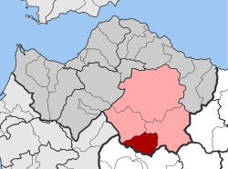 | |
| Coordinates: 37°48′N 22°1′E / 37.800°N 22.017°ECoordinates: 37°48′N 22°1′E / 37.800°N 22.017°E | |
| Country | Greece |
| Administrative region | West Greece |
| Regional unit | Achaea |
| Municipality | Kalavryta |
| Districts | 7 |
| • Municipal unit | 99.325 km2 (38.350 sq mi) |
| Highest elevation | 1,808 m (5,932 ft) |
| Lowest elevation | 600 m (2,000 ft) |
| Population (2011)[1] | |
| • Municipal unit | 1,055 |
| • Municipal unit density | 11/km2 (28/sq mi) |
| Time zone | UTC+2 (EET) |
| • Summer (DST) | UTC+3 (EEST) |
| Postal code | 260 05 |
| Vehicle registration | AX |
Paion (Greek: Παΐων) is a former municipality in Achaea, West Greece, Greece. Its population in 2011 was 1,055. The seat of the municipality was in Dafni. The municipality was created after the Greek War of Independence and was dissolved in 1912. It was recreated in 1998 under the Capodistrian Plan. Since the 2011 local government reform it is part of the municipality Kalavryta, of which it is a municipal unit.[2] The municipal unit has an area of 99.325 km2.[3]
Subdivisions
The municipal unit Paion is subdivided into the following communities (constituent villages in brackets):
Population
| Year | Population |
|---|---|
| 1991 | 2,623 |
| 2001 | 2,579 |
| 2011 | 1,055 |
Mayors
- Papadimitrakopoulos (1907–1912) [4]
References
- ↑ "Απογραφή Πληθυσμού - Κατοικιών 2011. ΜΟΝΙΜΟΣ Πληθυσμός" (in Greek). Hellenic Statistical Authority.
- ↑ Kallikratis law Greece Ministry of Interior (in Greek)
- ↑ "Population & housing census 2001 (incl. area and average elevation)" (PDF) (in Greek). National Statistical Service of Greece.
- ↑ Empros, 7-5-1907
External links
Places adjacent to Paion | ||||||||||
|---|---|---|---|---|---|---|---|---|---|---|
| ||||||||||
This article is issued from
Wikipedia.
The text is licensed under Creative Commons - Attribution - Sharealike.
Additional terms may apply for the media files.