Paint Lick, Kentucky
| Paint Lick, Kentucky | |
|---|---|
| Unincorporated community | |
| Nickname(s): "The Jewel Of Garrard County" [unofficial] | |
 Paint Lick Location within the state of Kentucky  Paint Lick Paint Lick (the US) | |
| Coordinates: 37°37′0″N 84°24′34″W / 37.61667°N 84.40944°WCoordinates: 37°37′0″N 84°24′34″W / 37.61667°N 84.40944°W | |
| Country | United States |
| State | Kentucky |
| County | Garrard |
| Elevation | 820 ft (250 m) |
| Time zone | UTC-5 (Eastern (EST)) |
| • Summer (DST) | UTC-4 (EDT) |
| ZIP codes | 40461 |
| GNIS feature ID | 500117 |
Paint Lick is an unincorporated community in Garrard County, Kentucky, United States. It lies along Routes 21 and 52 east of the city of Lancaster. the county seat of Garrard County.[1] In 2015, a new route for KY 52 opened, bypassing the town, and essentially wiping it off the map. Its elevation is 820 feet (250 m).[2] Although it is unincorporated, it has a post office, with the ZIP code of 40461.[3] Historic sites within the community include Paint Lick Presbyterian Church (1879).
References
- ↑ Rand McNally. The Road Atlas '06. Chicago: Rand McNally, 2006, p. 43.
- ↑ U.S. Geological Survey Geographic Names Information System: Paint Lick, Kentucky, Geographic Names Information System, 1979-09-20. Accessed 2008-01-03.
- ↑ Zip Code Lookup
Municipalities and communities of Garrard County, Kentucky, United States | ||
|---|---|---|
| City | 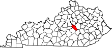 | |
| Unincorporated communities | ||
This article is issued from
Wikipedia.
The text is licensed under Creative Commons - Attribution - Sharealike.
Additional terms may apply for the media files.