Overland, Nebraska
| Overland, Nebraska | |
|---|---|
| Census-designated place | |
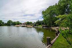 The Platte River | |
 Overland Location within the state of Nebraska | |
| Coordinates: 41°4′52″N 97°58′43″W / 41.08111°N 97.97861°WCoordinates: 41°4′52″N 97°58′43″W / 41.08111°N 97.97861°W | |
| Country | United States |
| State | Nebraska |
| County | Hamilton |
| Area | |
| • Total | 1.4 sq mi (3.7 km2) |
| • Land | 1.2 sq mi (3.1 km2) |
| • Water | 0.2 sq mi (0.6 km2) |
| Elevation | 1,699 ft (518 m) |
| Population (2010) | |
| • Total | 153 |
| • Density | 110/sq mi (41/km2) |
| Time zone | UTC-6 (Central (CST)) |
| • Summer (DST) | UTC-5 (CDT) |
| Area code(s) | 402 |
| GNIS feature ID | 0835400[1] |
Overland is a census-designated place (CDP) in Hamilton County, Nebraska, United States. The population was 153 at the 2010 census.[2]
Geography
Overland is located at 41°4′52″N 97°58′43″W / 41.08111°N 97.97861°W (41.0813, -97.9787). According to the United States Census Bureau, the CDP has a total area of 1.4 square miles (3.7 km2), of which 1.2 square miles (3.1 km2) is land and 0.23 square miles (0.6 km2), or 16.23%, is water.[3] The community is located along the south side of the Platte River, along Nebraska Highway 66 and east of Nebraska Highway 14, 3 miles (5 km) south of Central City.
References
- ↑ "US Board on Geographic Names". United States Geological Survey. 2007-10-25. Retrieved 2008-01-31.
- ↑ "Profile of General Population and Housing Characteristics: 2010 Demographic Profile Data (DP-1): Overland CDP, Nebraska". U.S. Census Bureau, American Factfinder. Retrieved April 5, 2012.
- ↑ "Geographic Identifiers: 2010 Demographic Profile Data (G001): Overland CDP, Nebraska". U.S. Census Bureau, American Factfinder. Retrieved April 5, 2012.
This article is issued from
Wikipedia.
The text is licensed under Creative Commons - Attribution - Sharealike.
Additional terms may apply for the media files.