Ovapa, West Virginia
| Ovapa, West Virginia | |
|---|---|
| Unincorporated community | |
 Ovapa | |
| Coordinates: 38°31′17″N 81°08′55″W / 38.52139°N 81.14861°WCoordinates: 38°31′17″N 81°08′55″W / 38.52139°N 81.14861°W | |
| Country | United States |
| State | West Virginia |
| County | Clay |
| Elevation | 876 ft (267 m) |
| Time zone | UTC-5 (Eastern (EST)) |
| • Summer (DST) | UTC-4 (EDT) |
| ZIP Codes | 25120 |
| Area code(s) | 304 & 681 |
| GNIS feature ID | 1555285[1] |
Ovapa is an unincorporated community in Clay County, West Virginia, United States. Ovapa is 5.5 miles (8.9 km) northwest of Clay.
The community's name most likely is an amalgamation of Ohio, Virginia, and Pennsylvania.[2]
References
- ↑ U.S. Geological Survey Geographic Names Information System: Ovapa, West Virginia
- ↑ Kenny, Hamill (1945). West Virginia Place Names: Their Origin and Meaning, Including the Nomenclature of the Streams and Mountains. Piedmont, WV: The Place Name Press. p. 465.
Municipalities and communities of Clay County, West Virginia, United States | ||
|---|---|---|
| Town | 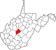 | |
| Unincorporated communities |
| |
| Footnotes | ‡This populated place also has portions in an adjacent county or counties | |
This article is issued from
Wikipedia.
The text is licensed under Creative Commons - Attribution - Sharealike.
Additional terms may apply for the media files.