Clarksville–Montgomery County Regional Airport
| Clarksville–Montgomery County Regional Airport John F. Outlaw Field | |||||||||||||||
|---|---|---|---|---|---|---|---|---|---|---|---|---|---|---|---|
|
| |||||||||||||||
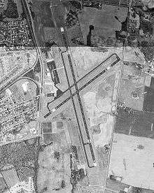 USGS aerial image, 27 March 1992 | |||||||||||||||
| Summary | |||||||||||||||
| Airport type | Public | ||||||||||||||
| Owner | City of Clarksville & Montgomery County | ||||||||||||||
| Serves | Clarksville, Tennessee | ||||||||||||||
| Elevation AMSL | 550 ft / 168 m | ||||||||||||||
| Coordinates | 36°37′19″N 087°24′54″W / 36.62194°N 87.41500°WCoordinates: 36°37′19″N 087°24′54″W / 36.62194°N 87.41500°W | ||||||||||||||
| Website |
www | ||||||||||||||
| Map | |||||||||||||||
 Outlaw Field Location of airport in Tennessee | |||||||||||||||
| Runways | |||||||||||||||
| |||||||||||||||
| Statistics (2009) | |||||||||||||||
| |||||||||||||||
Clarksville–Montgomery County Regional Airport[1] (IATA: CKV, ICAO: KCKV, FAA LID: CKV), also known as John F. Outlaw Field[1] or simply Outlaw Field,[2] is a public use airport located six nautical miles (11 km) northwest of the central business district of Clarksville, a city in Montgomery County, Tennessee, United States.[2] It is owned by the city of Clarksville and Montgomery County.[2] The airport is located near Fort Campbell.
History
It opened in 1937 as a private airport. It was taken over by the United States Army Air Corps during World War II and became known as Clarksville Army Airfield. It was established as a sub-base for the larger Campbell Army Airfield in Fort Campbell, Kentucky and was activated on 1 June 1942 as a primary basic flying training (level 1) airfield. It conducted flying training until inactivated on 31 October 1945. It remained inactive until transferred to USAF Tactical Air Command on 31 March 1946 and remained under USAF control until 1959 when the Air Force turned over all airport facilities to the United States Army. In 1960 it returned to public airport status[3][4][5]
Facilities and aircraft
Outlaw Field covers an area of 452 acres (183 ha) at an elevation of 550 feet (168 m) above mean sea level. It has two asphalt paved runways: 17/35 is 6,000 by 100 feet (1,829 x 30 m) and 5/23 is 4,004 by 100 feet.[2]
For the 12-month period ending December 15, 2009, the airport had 20,600 aircraft operations, an average of 56 per day: 89% general aviation, 10% military, and 1% air taxi. At that time there were 40 aircraft based at this airport: 75% single-engine, 20% multi-engine, 2.5% jet and 2.5% helicopter.[2]
Future
Outlaw Field had its terminal reconstructed in the year 2011. The ground breaking was first started on December 17, 2010. The terminal was fully reconstructed by spring 2012.
See also
References
- 1 2 3 Clarksville–Montgomery County Regional Airport (John F. Outlaw Field), official web site
- 1 2 3 4 5 6 FAA Airport Master Record for CKV (Form 5010 PDF). Federal Aviation Administration. Effective 8 April 2010.
- ↑

- ↑ Shaw, Frederick J. (2004), Locating Air Force Base Sites History’s Legacy, Air Force History and Museums Program, United States Air Force, Washington DC, 2004.
- ↑ Manning, Thomas A. (2005), History of Air Education and Training Command, 1942–2002. Office of History and Research, Headquarters, AETC, Randolph AFB, Texas ASIN: B000NYX3PC
External links
- FAA Terminal Procedures for CKV, effective October 11, 2018
- Resources for this airport:
- FAA airport information for CKV
- AirNav airport information for KCKV
- ASN accident history for CKV
- FlightAware airport information and live flight tracker
- NOAA/NWS latest weather observations
- SkyVector aeronautical chart, Terminal Procedures
| Air Forces |  | ||||||
|---|---|---|---|---|---|---|---|
| Air Divisions | |||||||
| Named units | |||||||
| Wings |
| ||||||
| Former bases |
| ||||||
| Aircraft |
| ||||||