Arrondissement of Oudenaarde
| Arrondissement of Oudenaarde Arrondissement Oudenaarde | |
|---|---|
| Arrondissement | |
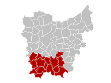
 Location of the arrondissement in East-Flanders | |
| Coordinates: 50°51′N 3°36′E / 50.85°N 3.6°ECoordinates: 50°51′N 3°36′E / 50.85°N 3.6°E | |
| Country |
|
| Region |
|
| Province |
|
| Municipalities | 11 |
| Area | |
| • Total | 418.80 km2 (161.70 sq mi) |
| Population (1 January 2017) | |
| • Total | 123,330 |
| • Density | 290/km2 (760/sq mi) |
| Time zone | UTC+1 (CET) |
| • Summer (DST) | UTC+2 (CEST) |
Location of the judicial arrondissement in East-Flanders
The Arrondissement of Oudenaarde (Dutch: Arrondissement Oudenaarde; French: Arrondissement d'Audenarde) is one of the six administrative arrondissements in the Province of East Flanders, Belgium. It is both an administrative and a judicial arrondissement. However, the Judicial Arrondissement of Oudenaarde also comprises the municipalities of Geraardsbergen, Herzele, Sint-Lievens-Houtem and Zottegem in the Arrondissement of Aalst.
Municipalities
The Administrative Arrondissement of Oudenaarde consists of the following municipalities:
|
|
|
Per 1 January 2019, the municipalities of Kruishoutem and Zingem will merge into the new municipality of Kruisem.
| Judicial area of Antwerp | |
|---|---|
| Judicial area of Brussels | |
| Judicial area of Ghent | |
| Judicial area of Liège | |
| Judicial area of Mons | |
This article is issued from
Wikipedia.
The text is licensed under Creative Commons - Attribution - Sharealike.
Additional terms may apply for the media files.