Otautau
| Otautau | |
|---|---|
 Otautau | |
| Coordinates: 46°08′34″S 167°59′59″E / 46.14278°S 167.99972°ECoordinates: 46°08′34″S 167°59′59″E / 46.14278°S 167.99972°E | |
| Country |
|
| Region | Southland Region |
| Otautau | 1861 |
| Elevation | 60 m (200 ft) |
| Population (2006) | |
| • Total | 753 |
| Time zone | UTC+12:00 (NZST) |
| Postal code | 9610 (rural: 9682 9683 9689) [1] |
| Local iwi | Ngāi Tahu |
Otautau is a small farming, forestry and milling town (population 753 as of 2006 census)[2] located inland on the western edge of the Southland Plains of New Zealand on the banks of the Aparima River.[3] Otautau is located approximately 40 km north west of Invercargill.[4] The average elevation of Otautau is 60 meters.[5]
Otautau is also known as “The Heart of Western Southland”.[6]
History
Otautau was founded after the discovery of gold in Central Otago in 1861 (Central Otago Gold Rush) to meet the needs of travelers on their way to the then newly discovered gold fields.[7]
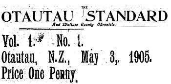
Otautau Standard and Wallace County Chronicle
Otautau was home to the Otautau Standard and Wallace County Chronicle from 1905 until publication ceased in 1946. The Otautau Standard was a weekly newspaper started by Frank Hyde. In 1906 Hyde sold the newspaper to John Fisher. The Fisher family remained in charge until its closure.[8]
Otautau war memorial
The Otautau war memorial is on Main Street, Otautau. It was opened by Prime Minister William Massey in 1922 and contains the names of local soldiers who died in World War I and World War II. Two canopied guns from Turkish and German forces are on either side of the memorial.[9]
Forestry
Soon after World War II the New Zealand Forest Service began operating from Otautau. The planting of alien species began in 1949 and grew rapidly from the middle of the 1960s as a direct result of seasonal labour.[7]
Festivals
References
- ↑ http://tools.nzpost.co.nz/tools/address-postcode-finder/APLT2008.aspx
- ↑ Quickstats about Otautau
- ↑ Google Maps - Otautau.
- ↑ Otautau - Town profile.
- ↑ "Mongabay - Population Profile (Otautau)".
- ↑ Overview of Otautau.
- 1 2 A Case Study of OTAUTAU (June 1998) November 25, 2010.
- ↑ New Zealand National Library (Past Papers).
- ↑ New Zealand History Online - Otautau war memorial.
- ↑ "You 'n' Lamb Festival at Otautau". The Southland Times. November 9, 2010. Retrieved November 1, 2011.
- ↑ Meat Trade News Daily Printed 21/11/2010.
External links
Further reading
- Bye, K. 1988. Trial By Fire, Trial By Water. History of Otautau. Otautau [N.Z.] : Published by the Centennial Book Committee on behalf of the Otautau Community Council, c1988. ISBN 0-473-00649-9 (hbk.)
- The Cyclopedia of New Zealand.