Dacre, New Zealand

Dacre is the name of a small town in the South Island of New Zealand. It is situated on the Southland Plains between Invercargill and Edendale on State Highway 1. In Dacre, SH 1 is met by New Zealand State Highway 98 (Lorneville - Dacre Road), which runs west to Makarewa via Rakahouka. Nearby villages include Mabel Bush to the northwest and Woodlands to the southeast. Dacre is 25 km north east of Invercargill, the closest city. The Main South Line railway passes just to the south of Dacre. It is a dairy farming community, that currently has a community hall and a small engine garage.
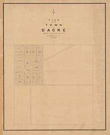
The town was first surveyed in December 1863 by Theophilus Heale, who was the chief surveyor of the region. It appears to be unknown where the name "Dacre" comes from, further backed up by an article from the Mataura Ensign in 1912, which states that:
- "[Dacre] has a foreign appearance but by whom given the writer cannot say. (The old name of this locality was Halfway Bush, so named by Mr W. H. S. Roberts because it was midway between his house at Titipua [possibly a variation in the spelling of Te Tipua] and that of Mr McClymont's.)"[1]
Dacre used to have a primary school, in a building that was originally set up as a hotel,[2] however it was closed after 108 years of operation due to a dwindling number of students. Dacre Primary School closed at the end of 2008 with a roll of 5 students.[3] When the school celebrated its centenary in 1999, it had two teachers.[4]
References
- ↑ Beatie, H. (2 September 1912). "Place Names - Southern New Zealand" (Newspaper article). Papers Past New Zealand. Mataura Ensigtn. Retrieved 2 January 2017.
- ↑ Cyclopedia Company Limited (1905). "Dacre". New Zealand Electronic Text Collection. The Cyclopedia Company, Limited,. Retrieved 26 October 2015.
- ↑ "108-year era ends as Dacre Primary closes its doors". stuff.co.nz. The Southland Times. Retrieved October 6, 2014.
- ↑ Grant, David (May 25, 2015). "Southland places - Around Invercargill". Te Ara - the Encyclopedia of New Zealand. Retrieved 8 September 2015.
Coordinates: 46°19′S 168°38′E / 46.317°S 168.633°E