Oslava
| Oslava | |
|---|---|
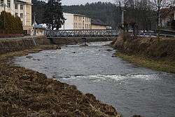 Oslava River in Velké Meziříčí | |
| Country | Czech Republic |
| Physical characteristics | |
| Main source | Bohemian-Moravian Highlands |
| River mouth |
Jihlava River 49°5′51″N 16°21′51″E / 49.09750°N 16.36417°ECoordinates: 49°5′51″N 16°21′51″E / 49.09750°N 16.36417°E |
| Length | 99.2 km (61.6 mi) |
| Discharge |
|
| Basin features | |
| Progression | Jihlava→ Svratka→ Thaya→ Morava→ Danube→ Black Sea |
| Basin size | 867 km2 (335 sq mi) |
Oslava is a river in the Czech Republic, the left tributary of the Jihlava River. It originates in the Bohemian-Moravian Highlands (Českomoravská vrchovina) upland at the elevation of 567 m and flows to Ivančice, where it enters the Jihlava River. It is 99.2 km long, and its basin area is 867 km2.[1]
It flows through numerous towns and villages, including Nové Veselí, Ostrov nad Oslavou, Velké Meziříčí, Náměšť nad Oslavou, Oslavany and Ivančice. The Mostiště Dam is constructed on the river.
Its longest tributaries are the Balinka and Chvojnice rivers.
References
| Wikimedia Commons has media related to Oslava. |
- ↑ "Charakteristiky toků a povodí ČR - Oslava" (in Czech). VÚV TGM. Retrieved 2018-05-08.
This article is issued from
Wikipedia.
The text is licensed under Creative Commons - Attribution - Sharealike.
Additional terms may apply for the media files.