Opunake
| Opunake | |
|---|---|
| Minor urban area | |
 Opunake  Opunake | |
| Coordinates: 39°27′S 173°51′E / 39.450°S 173.850°ECoordinates: 39°27′S 173°51′E / 39.450°S 173.850°E | |
| Country |
|
| Region | Taranaki |
| Territorial authority | South Taranaki District |
| Area | |
| • Urban | 3.73 km2 (1.44 sq mi) |
| Population (June 2017)[1] | |
| • Urban | 1,360 |
| • Urban density | 360/km2 (940/sq mi) |
| Postcode | 4616 |

Opunake is a small town on the southwest coast of Taranaki in New Zealand's North Island. It is located 45 kilometres southwest of New Plymouth. Rahotu is 16 km to the northwest. Manaia is 29 km to the southeast. State Highway 45 passes through the town.[2][3]
The town has a population of 1,360 (June 2017).[1]
The town was settled in the 1880s.[4] It was intended to be a major port but, other than a jetty constructed in 1891, little else was completed.
Opunake is the centre for the local dairy industry, and is also a popular tourist spot, having one of Taranaki's finest beaches. The beach is composed of volcanic blacksand and there are large rock pools to be found on the north-west end of the beach at low tide.
Currently (January 2008) an artificial surfing reef is under construction in the northwestern corner of the beach.
The Opunake and surrounding community has a South Taranaki District Council LibraryPlus, which provides full library and Council related services.
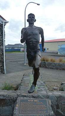
A statue of Peter Snell was unveiled on Saturday 19 May 2007 to celebrate the fame of this son of Opunake. Other notable people born in Opunake include former All Black captain Graham Mourie, prop Carl Hayman and former New Zealand Prime Minister Jim Bolger.
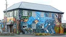
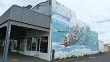
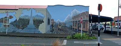
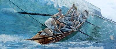
Opunake murals
From a rich farming history to Māori culture and modern industry, this set of wall murals found along the main road in the town of Opunake, Taranaki give just a little insight into what this region is about.
Assorted Wall Murals called "Reflections of Opunake" 1900 - 2000 Commissioned by the Egmont Arts Council. Designed and Painted by Mural Artist Dennis Lattimer during April/May 2002. Opunake, Taranaki, North Island, New Zealand.[5]
Education
Opunake High School is a coeducational secondary (years 9-13) school with a roll of 319 students as of August 2018.[6] The school celebrated its 75th jubilee in 2000.[7]
Opunake School, St Joseph's School, and Te Kura Kaupapa Maori o Tamarongo are full primary (years 1-8) schools with rolls of 216, 92 and 11 respectively.[6] St Joseph's is a state integrated Catholic school. Te Kura Kaupapa Maori o Tamarongo is a Kura Kaupapa Māori school which teaches in the Māori language.
See also
Notes
- 1 2 "Subnational Population Estimates: At 30 June 2017 (provisional)". Statistics New Zealand. 24 October 2017. Retrieved 24 October 2017. For urban areas, "Subnational population estimates (UA, AU), by age and sex, at 30 June 1996, 2001, 2006-16 (2017 boundary)". Statistics New Zealand. 24 October 2017. Retrieved 24 October 2017.
- ↑ Peter Dowling (editor) (2004), Reed New Zealand Atlas, Reed Books, map 34, ISBN 0-7900-0952-8
- ↑ Roger Smith, GeographX (2005), The Geographic Atlas of New Zealand, Robbie Burton, map 96, ISBN 1-877333-20-4
- ↑ "Opunake Travel Guide". Jasons Travel Media.
- ↑ http://www.new-zealand-pictures.co.nz/
- 1 2 "Directory of Schools - as at 13 September 2018". New Zealand Ministry of Education. Retrieved 22 September 2018.
- ↑ "Jubilees & reunions - Opunake High School", Education Gazette New Zealand, 78 (16), 13 September 1999