Opak River
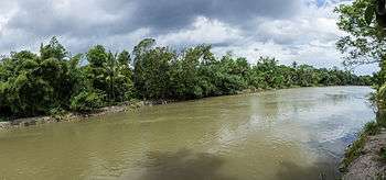
Opak River as viewed from Jetis, Bantul
Opak River is a river that flows from its source on the slopes of Mount Merapi in the north, heading southward and passes the west side of 9th-century Prambanan temple compound, located to the east of Yogyakarta and west of Kota Gede.
It also passes the historical locations of Plered, Karta, and Imogiri before draining into the Indian Ocean in the southern part of Bantul.
The river runs upon Opak tectonic fault, a major tectonic fault in southern Central Java responsible for major earthquakes in the region..
The river basin that it lies in is significant as the aquifer is in a heavily populated part of Java [1]
Notes
- ↑ Purnama, Setiawan; Suyono, Suyono; Sulaswono, Budi (2007), SISTEM AKUIFER DAN POTENSI AIRTANAH DAERAH ALIRAN SUNGAI (DAS) OPAK Aquifer System and Groundwater Potency of Opak River Basin, forum geografi, retrieved 5 March 2014
External links
Further reading
- (In Indonesian with English summaries) Sunarto Drs (2000), Studi geografi pertumbuhan bura dengan acuan pranata mangsa pada muara Sungai Opak dan Progo, Daerah Istimewa Yogyakarta : laporan penelitian, Lembaga Penelitian, Universitas Gadjah Mada, Departemen Pendidikan Nasional, retrieved 13 April 2012
This article is issued from
Wikipedia.
The text is licensed under Creative Commons - Attribution - Sharealike.
Additional terms may apply for the media files.