Oodnadatta
| Oodnadatta South Australia | |||||||||||||||
|---|---|---|---|---|---|---|---|---|---|---|---|---|---|---|---|
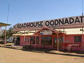 The Pink Roadhouse at Oodnadatta | |||||||||||||||
 Oodnadatta | |||||||||||||||
| Coordinates | 27°32′53″S 135°26′44″E / 27.54811°S 135.445432°ECoordinates: 27°32′53″S 135°26′44″E / 27.54811°S 135.445432°E[1] | ||||||||||||||
| Population | 166 (2011 census)[2] | ||||||||||||||
| Established |
30 October 1890 (town) 8 February 2001 (locality)[3][1] | ||||||||||||||
| Postcode(s) | 5734[4] | ||||||||||||||
| Elevation | 121 m (397 ft)(railway station)[5] | ||||||||||||||
| Location |
| ||||||||||||||
| LGA(s) | Pastoral Unincorporated Area[1] | ||||||||||||||
| Region | Far North[1] | ||||||||||||||
| State electorate(s) | Giles[6] | ||||||||||||||
| Federal Division(s) | Grey[7] | ||||||||||||||
| |||||||||||||||
| |||||||||||||||
| Footnotes |
Locations[1][4] Adjoining localities[1] | ||||||||||||||
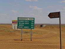
Oodnadatta, in the Australian state of South Australia, is a small town surrounded by an area of 7,800 square kilometres (3,000 sq mi) with cattle stations in arid pastoral rangelands close to the Simpson Desert, 873 kilometres (542 mi) north of the state capital of Adelaide and 112 m above sea level. It can be reached by an unsealed road from Coober Pedy or via the unsealed Oodnadatta Track from Marree to Marla or from the north via Finke, Northern Territory ("Old Ghan Heritage Trail"). The name is derived from Arrernte utnadata, meaning "mulga blossom".[9]
The population was 229 in 1976 and decreased to 160 in 1986. The 2006 census reported a population of 277 (150 male, 127 female, including 103 indigenous Australians).[2]
History
European exploration
John McDouall Stuart explored the region in 1859. The route mapped by Stuart in his journeys of 1857 to 1862 was adopted as part of the Overland Telegraph Line route. There was no township at Oodnadatta when the telegraph was built. It was called the Yellow Waterhole, or Angle Pole (due to a sharp change in direction of the telegraph line), and later was known as Hookey's Waterhole.[10]
Angle Pole (27°30′13″S 135°24′57″E / 27.50363071°S 135.41585261°E) is the point near Oodnadatta where the direction of the Telegraph Line changed to a more northerly direction.[11] It is near the Peake cattle station.[12][13]
By the 1880s the telegraph route was being used by camel trains, led by cameleers from Afghanistan, who were specially brought to Australia for the task of hauling goods into Central Australia for use by pioneer settlers. Camels were the only pack animals capable of taking on a six-week journey in often extreme heat, through sandy terrain. When train travel arrived, many of these camels were left to run wild in the outback where they number in the tens of thousands today. Many Afghan men and their families eventually settled in Oodnadatta and Maree, some marrying into the Aboriginal community.
Central Australia Railway
Angle Pole was identified as the proposed terminus for the extension of the Great Northern Railway in the 1880s. When the railway was built, a town was established at the terminus, and named Oodnadatta.[14]
Oodnadatta became the terminus of the Great Northern Railway in 1890,[15] and remained so until the line was extended to Alice Springs in 1929. The line became known as the Central Australia Railway and the train service on the line was known as the Ghan in honour of the Afghan cameleers. The railway was built with narrow gauge (1,067 mm (3 ft 6 in)) tracks; train traffic was frequently disrupted by washouts and other damage to the trackbed leading to a slow and unreliable service. The Algebuckina Bridge is nearby. The railway through Oodnadatta was closed in 1981; a new standard gauge line was built to the west bypassing Oodnadatta.
Both the historic Oodnadatta railway station, now a museum, and the nearby Algebuckina Bridge are listed on the South Australian Heritage Register.[16][17]
Roebuck Bay railway
Angle Pole was also proposed as the southeastern terminus of a still-born land grant railway from Roebuck Bay in Western Australia across the border to Angle Pole. This railway was proposed by a London syndicate around 1889 and would have been about 1000 miles (1600 km) long.[12]
While one or two land grant railways in Australia did succeed, this one was still-born.
The Roebuck Bay railway was proposed to be 1,600 mm (5 ft 3 in) gauge, presumably to link up with railways of that gauge between Terowie and Hamley Bridge to the colonial (later State) capital cities of Adelaide and Melbourne, implying that existing narrow railways of 1,067 mm (3 ft 6 in) north of Terowie and Hamley Bridge would have to be bypassed or converted as South Australian Railways had built its railway line as 1,067 mm (3 ft 6 in).
World War II
Oodnadatta's busiest era was World War II when the Australian Army and the Royal Australian Air Force set up local facilities to service troop trains and fighter aircraft en route to Darwin. Following the closure of the railway line in 1981, Oodnadatta, formerly a government service centre and supply depot for surrounding pastoral properties, became a residential freehold town for Indigenous Australians who, moving from cattle work, bought empty houses as railway workers left. Increasing tourist traffic along the Oodnadatta Track and an emerging mining industry keep the village alive. The Aboriginal school is the biggest employer.[9]
Life in Oodnadatta
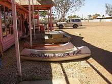
The Pink Roadhouse (so-called because it is painted bright pink) is a focal point for the town, providing petrol, a general store, meals, post office facilities and canoe hire. Although they really do have canoes (also painted bright pink), it is not clear where to use them in the surrounding area unless the local waterholes are recently filled.
Oodnadatta is serviced twice weekly by the Coober Pedy Oodnadatta One Day Mail Run. The OKA mail truck also carries some general freight and passengers.[18] Road trains bring weekly supplies of food and fuel etc. from Adelaide. Royal Flying Doctor Service and charter flights use the Oodnadatta Progress Associations' local all-weather Second World War airstrip which houses an automatic weather station.
There is a museum in the old Ghan railway station, and a medical centre. The railway station comprises a large and imposing Victorian-era home built for the stationmaster's family, with verandahs on three sides, very high ceilings for coolness, and a cellar. Abutting the stationmaster's residence is the railway station office itself. The whole precinct has been kept in very good condition since the line closed.
Oodnadatta elsewhere
The name Oodnadatta has been used as a name for a crater on the planet Mars.[19]
Climate
Oodnadatta has a hot desert climate (Köppen climate classification BWh) and has also recorded the highest reliably measured maximum temperature in Australia: 50.7 °C (123.3 F) on 2 January 1960. A higher temperature was recorded at Cloncurry in 1889; however, this has since been shown to have been recorded in a non-standard enclosure and likely to have been considerably cooler than first believed.[20] There is a large sign in Oodnadatta claiming the town is "The driest town, the driest state of the driest Continent".[21]
| Climate data for Oodnadatta (Airport 1939–2016) | |||||||||||||
|---|---|---|---|---|---|---|---|---|---|---|---|---|---|
| Month | Jan | Feb | Mar | Apr | May | Jun | Jul | Aug | Sep | Oct | Nov | Dec | Year |
| Record high °C (°F) | 50.7 (123.3) |
46.8 (116.2) |
44.9 (112.8) |
42.1 (107.8) |
35.0 (95) |
32.8 (91) |
32.2 (90) |
36.5 (97.7) |
40.7 (105.3) |
45.4 (113.7) |
47.3 (117.1) |
48.3 (118.9) |
50.7 (123.3) |
| Average high °C (°F) | 37.8 (100) |
36.6 (97.9) |
33.7 (92.7) |
28.5 (83.3) |
23.2 (73.8) |
19.9 (67.8) |
19.6 (67.3) |
22.1 (71.8) |
26.6 (79.9) |
30.2 (86.4) |
33.7 (92.7) |
36.3 (97.3) |
29.0 (84.2) |
| Daily mean °C (°F) | 30.4 (86.7) |
29.5 (85.1) |
26.5 (79.7) |
21.5 (70.7) |
16.5 (61.7) |
13.2 (55.8) |
12.7 (54.9) |
14.8 (58.6) |
19.0 (66.2) |
22.7 (72.9) |
26.1 (79) |
29.3 (84.7) |
21.9 (71.4) |
| Average low °C (°F) | 23.0 (73.4) |
22.3 (72.1) |
19.2 (66.6) |
14.4 (57.9) |
9.7 (49.5) |
6.5 (43.7) |
5.8 (42.4) |
7.4 (45.3) |
11.4 (52.5) |
15.1 (59.2) |
18.5 (65.3) |
21.2 (70.2) |
14.5 (58.1) |
| Record low °C (°F) | 11.7 (53.1) |
12.8 (55) |
9.5 (49.1) |
3.8 (38.8) |
0.9 (33.6) |
−2.6 (27.3) |
−2.2 (28) |
−0.3 (31.5) |
2.2 (36) |
5.1 (41.2) |
9.6 (49.3) |
11.3 (52.3) |
−2.6 (27.3) |
| Average precipitation mm (inches) | 22.9 (0.902) |
32.2 (1.268) |
14.1 (0.555) |
11.1 (0.437) |
12.8 (0.504) |
11.8 (0.465) |
10.0 (0.394) |
8.1 (0.319) |
9.9 (0.39) |
13.9 (0.547) |
13.0 (0.512) |
17.1 (0.673) |
177.1 (6.972) |
| Average precipitation days (≥ 0.2 mm) | 2.9 | 2.8 | 2.3 | 2.3 | 2.7 | 3.0 | 2.5 | 2.4 | 2.7 | 3.6 | 3.6 | 3.5 | 34.3 |
| Mean monthly sunshine hours | 337.9 | 315.0 | 313.1 | 273.0 | 244.9 | 231.0 | 254.2 | 275.9 | 291.0 | 316.2 | 321.0 | 341.0 | 3,514.2 |
| Source: Bureau of Meteorology [8] | |||||||||||||
References
- 1 2 3 4 5 6 "Search results for 'Oodnadatta, LOCB' with the following datasets selected – 'Suburbs and Localities', "Counties', 'Government Towns', 'Local Government Areas', 'SA Government Regions' and 'Gazetteer'". Location SA Map Viewer. Government of South Australian Government. Retrieved 13 May 2018.
- 1 2 Australian Bureau of Statistics (25 October 2007). "Oodnadatta (State Suburb)". 2006 Census QuickStats. Retrieved 2008-02-28.
- ↑ Bray, J.C. (30 October 1890). "Untitled proclamation (Town of Oodnadatta)" (PDF). The South Australian Government Gazette. South Australian Government. p. 1068. Retrieved 13 May 2018.
- 1 2 "Postcode for Oodnadatta, South Australia". Postcodes Australia. Retrieved 13 May 2018.
- ↑ "Search results for 'Oodnadatta Railway Station' with the following datasets selected – 'Suburbs and Localities', 'Government Towns' and 'Gazetteer'". Location SA Map Viewer. Government of South Australian Government. Retrieved 13 May 2018.
- ↑ "District of Giles Background Profile". Electoral Commission SA. Retrieved 12 February 2018.
- ↑ "Federal electoral division of Grey" (PDF). Australian Electoral Commission. Retrieved 12 February 2018.
- 1 2 3 4 "Climate Statistics for Oodnadatta Airport". Climate statistics for Australian locations. Bureau of Meteorology. Retrieved March 31, 2013.
- 1 2 "Outback: The Oodnadatta Track". National Roads and Motorists' Association (NRMA). Archived from the original on 6 August 2008. Retrieved 24 June 2008.
- ↑ "Alfred Giles – Enjoying Life at 80". The Mail. Adelaide: National Library of Australia. 22 September 1928. p. 3. Retrieved 30 January 2013.
- ↑ http://www.exploroz.com/Places/77748/SA/The_Angle_Pole_Memorial.aspx
- 1 2 "RAILWAY CONSTRUCTION IN WESTERN AUSTRALIA". The Sydney Morning Herald. National Library of Australia. 14 February 1889. p. 7. Retrieved 28 December 2012.
- ↑ "Search result for "Angle Pole" (Record No. SA0001492)". Department of Planning Transport and infrastructure. 1 July 2004. Retrieved 29 October 2015.
- ↑ "PUBLIC WORKS AND RAILWAYS". South Australian Chronicle. XXXII, (1, 637). South Australia. 4 January 1890. p. 9. Retrieved 22 March 2017 – via National Library of Australia.
- ↑ Great Northern to Government Gums – A Mineral Railway Callaghan, W.H. Australian Railway History, September;October, 2008 pp283-301;323-336
- ↑ "Museum (former Oodnadatta Railway Complex, including Station/Residence, Goods Shed and Crane)". South Australian Heritage Register. Department of Environment, Water and Natural Resources. Retrieved 12 February 2016.
- ↑ "Algebuckina Railway Bridge over the Neales River [Metal Truss]". Department of Environment, Water and Natural Resources. South Australian Heritage Register. Retrieved 12 February 2016.
- ↑ "Coober Pedy Oodnadatta One Day Mail Run". Archived from the original on 3 May 2006.
- ↑ Categories for Naming Features on Planets and Satellites, Gazetteer of Planetary Nomenclature, USGS Astrogeology Science Center, NASA
- ↑ "Queensland to bake on Christmas Day". AM. Australian Broadcasting Corporation. 24 December 2003. Retrieved 17 November 2009.
- ↑ "Too Hot to Refuel as Town Bakes". Adelaide Now. 9 January 2013. Retrieved 9 January 2013.
External links
- Tracking History to Oodnadatta by Roderick Eime
- Pink Roadhouse Iconic landmark of Oodnadatta
- Oodnadatta Pioneer Cemetery with photos of headstones
- Coober Pedy Oodnadatta One Day Mail Run