Ona, Florida
| Ona, Florida | |
|---|---|
| Census-designated place | |
 Ona  Ona | |
| Coordinates: 27°28′55″N 81°55′08″W / 27.48194°N 81.91889°WCoordinates: 27°28′55″N 81°55′08″W / 27.48194°N 81.91889°W | |
| Country | United States |
| State | Florida |
| County | Hardee |
| Area[1] | |
| • Total | 26.718 sq mi (69.20 km2) |
| • Land | 26.718 sq mi (69.20 km2) |
| • Water | 0 sq mi (0 km2) |
| Elevation | 89 ft (27 m) |
| Population (2010)[2] | |
| • Total | 314 |
| • Density | 12/sq mi (4.5/km2) |
| Time zone | UTC-5 (Eastern (EST)) |
| • Summer (DST) | UTC-4 (EDT) |
| ZIP code | 33865 |
| Area code(s) | 863 |
| GNIS feature ID | 288156[3] |
Ona is an unincorporated community and census-designated place in Hardee County, Florida, United States. Its population was 314 as of the 2010 census.[2] Ona has a post office with ZIP code 33865, which opened on October 11, 1897.[4][5] State Road 64 and a CSX Transportation line pass through the community.
References
- ↑ "US Gazetteer files: 2010, 2000, and 1990". United States Census Bureau. 2011-02-12. Retrieved 2011-04-23.
- 1 2 "American FactFinder". United States Census Bureau. Retrieved 2011-05-14.
- ↑ "Ona". Geographic Names Information System. United States Geological Survey.
- ↑ United States Postal Service (2012). "USPS - Look Up a ZIP Code". Retrieved 2012-02-15.
- ↑ "Postmaster Finder - Post Offices by ZIP Code". United States Postal Service. Retrieved November 25, 2013.
Municipalities and communities of Hardee County, Florida, United States | ||
|---|---|---|
| Cities | 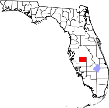 | |
| Town | ||
| CDPs | ||
| Unincorporated communities | ||
| Ghost town | ||
This article is issued from
Wikipedia.
The text is licensed under Creative Commons - Attribution - Sharealike.
Additional terms may apply for the media files.