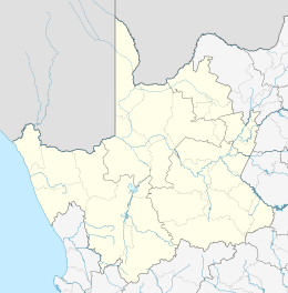
Olifantshoek
| Olifantshoek | |
|---|---|
 Olifantshoek  Olifantshoek Olifantshoek (South Africa)  Olifantshoek Olifantshoek (Africa) | |
| Coordinates: 27°56′S 22°44′E / 27.933°S 22.733°ECoordinates: 27°56′S 22°44′E / 27.933°S 22.733°E | |
| Country | South Africa |
| Province | Northern Cape |
| District | John Taolo Gaetsewe |
| Municipality | Gamagara |
| Established | 1912 |
| Area[1] | |
| • Total | 66.58 km2 (25.71 sq mi) |
| Population (2011)[1] | |
| • Total | 10,233 |
| • Density | 150/km2 (400/sq mi) |
| Racial makeup (2011)[1] | |
| • Black African | 42.5% |
| • Coloured | 47.7% |
| • Indian/Asian | 0.6% |
| • White | 5.5% |
| • Other | 3.8% |
| First languages (2011)[1] | |
| • Afrikaans | 78.9% |
| • Tswana | 10.2% |
| • English | 2.1% |
| • Sotho | 1.3% |
| • Other | 7.4% |
| Time zone | UTC+2 (SAST) |
| Postal code (street) | 8450 |
| PO box | 8450 |
| Area code | 053 |
Olifantshoek
Olifantshoek is a town in John Taolo Gaetsewe District Municipality in the Northern Cape Province of South Africa.
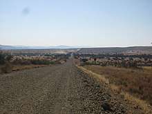
The village is 60 km northwest of Postmasburg and 80 km southwest of Kuruman. It developed from a police post and is administered by a village management board. The name is of Afrikaans origin and means "elephants' corner" or "elephants' glen", referring to the many elephant skeletons that Dutch settlers found in the area. It may also be translated from Tswana "ditlou".
History
The town was officially founded in 1912. The town was allegedly named after the tusk of an elephant that was used to purchase the farm on which the town was built. Many other elephant bones were found in the area.
Geography
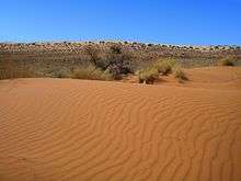
Olifantshoek lies at the foot of the Lange Mountains on the Namakwari Route in the Northern Cape Province of South Africa. For millions of years, a natural reservoir beneath the dunes has washed the red oxide out of the sand leaving white dunes which remain. These white dunes contrast against the rust-red sand of the rest of the Kalahari. During hot and dry conditions, the grains of sand rub together to create a deep hum. These sounds are best heard in close proximity to the dunes during the summer months between September and April. Rain silences the sounds of the dunes.[2][3]The town is also known as the ‘Gateway to the White and Roaring Sands’.[4]
Climate
Olifantshoek is situated within both the Savanna and Nama-Karoo biomes, and is a semi-arid region. Average yearly rainfall is 242mm per annum with the majority of the rain falling in summer [5]. Day temperatures often reach over 35 degrees Celsius in mid-summer. Winters are clear and dry, and, while daytime temperatures average 21 degrees Celsius, temperatures often drop below zero at night.
Attractions
Witsand Nature Reserve
The Witsand Nature Reserve has white sand dunes which are surrounded by contrasting red sand dunes. The reserve spans over 2,500 hectares of land with dunes up to 100 metres high and 10 kilometres in length. These white dunes are also known as the Kalahari Roaring Sands due to the sounds they make under certain weather conditions. The colouring of the dunes is believed to have been formed by numerous hills beneath the sand. Wildlife that can be observed in the nature reserve include meercats, pangolins and aardvarks. Larger antelope such as the red hartebeest, springbok, gemsbok and kudu can also be seen.[6] Nocturnal wildlife includes the porcupine, aardwolf, bat-eared fox, Cape fox, genet, springhare and owl.[7]
Hiking trails
The Neylan and the Pudu hiking trails are available for exploration in Olifantshoek.
San Rock Paintings
There are numerous engravings and San rock art paintings in the Olifantshoek area. Some of these can be viewed on Meerlust and Pan Heuwel farms.
War Grave
The war graves cemetery in Olifantshoek dates back to 1879. The graves are of the deceased during the Galeshewe wars fought between the inhabitants of the old Transvaal and the Tswana people on the western perimeter of the old Transvaal Republic.[8]These graves are on the Fuller farm.[9]
See also
External links
References
- 1 2 3 4 "Main Place Olifantshoek". Census 2011.
- ↑ https://www.sa-venues.com/game-reserves/nc_witsand.htm Accessed 12 January 2018
- ↑ https://www.wheretostay.co.za/town/olifantshoek Accessed 12 January 2018
- ↑ http://experiencenortherncape.com/visitor/cities-and-towns/olifantshoek Accessed 12 January 2018
- ↑ "Olifantshoek climate". www.saexplorer.co.za. Retrieved 2018-02-09.
- ↑ https://www.wheretostay.co.za/town/olifantshoek Accessed 12 January 2018
- ↑ https://www.sa-venues.com/game-reserves/nc_witsand.htm Accessed 12 January 2018
- ↑ https://www.wheretostay.co.za/town/olifantshoek Accessed 12 January 2018
- ↑ http://www.northern-cape-info.co.za/provinces/town/544 Accessed 13 January 2018
Municipalities and communities of John Taolo Gaetsewe District Municipality, Northern Cape | ||
|---|---|---|
District seat: Kuruman | ||
| Joe Morolong | .svg.png) | |
| Ga-Segonyana | ||
| Gamagara | ||