Old U.S. Route 64 (Scotia, Arkansas)
|
Old US 64, Scotia Segment | |
 | |
  | |
| Nearest city |
South of |
|---|---|
| Coordinates | 35°19′56″N 93°17′40″W / 35.33222°N 93.29444°WCoordinates: 35°19′56″N 93°17′40″W / 35.33222°N 93.29444°W |
| Area | less than one acre |
| Architectural style | Highway |
| MPS | Arkansas Highway History and Architecture MPS |
| NRHP reference # | 07000959[1] |
| Added to NRHP | September 19, 2007 |
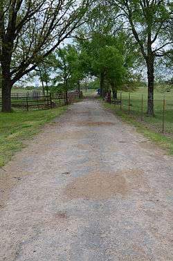
The Old US 64, Scotia Segment is a section of historic roadway in the rural hamlet of Scotia, Arkansas. It extends eastward from Country Lane, south of the current alignment of U.S. Route 64 (US 64). It is about 0.5 miles (0.80 km) in length, following an arced route, and is covered in a bituminous that has in places deteriorated into gravel. It is believed to be the longest-surviving element of the c. 1920 alignment of US 64 in Arkansas, and was built on an alignment dating to the 1830s. It is believed this road formed part of the Trail of Tears.[2]
The roadway was listed on the National Register of Historic Places in 2007.[1]
See also
References
- 1 2 National Park Service (2010-07-09). "National Register Information System". National Register of Historic Places. National Park Service.
- ↑ "NRHP nomination for Old US 64, Scotia Segment" (PDF). Arkansas Preservation. Retrieved 2016-05-02.
| Topics | |
|---|---|
| Lists by states |
|
| Lists by insular areas | |
| Lists by associated states | |
| Other areas | |
| |
This article is issued from
Wikipedia.
The text is licensed under Creative Commons - Attribution - Sharealike.
Additional terms may apply for the media files.