Ojstrica
| Ojstrica | |
|---|---|
 | |
| Highest point | |
| Elevation | 2,350 m (7,710 ft) |
| Coordinates | 46°21′50.220″N 14°38′14.064″E / 46.36395000°N 14.63724000°ECoordinates: 46°21′50.220″N 14°38′14.064″E / 46.36395000°N 14.63724000°E |
| Geography | |
 Ojstrica | |
| Parent range | Kamnik–Savinja Alps |
| Geology | |
| Age of rock | 250 million years |
| Mountain type | limestone |
| Climbing | |
| First ascent | 1823 by Ernest Joanelli |
| Easiest route | South |
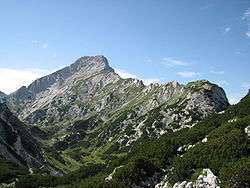
Ojstrica from Dleskovška planota
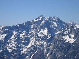
Ojstrica (2,350 meters or 7,710 feet) is a mountain in the eastern part of the Kamnik Alps with a pyramid-shaped top that is visible from far away. The name Ojstrica derives from the Slovene word oster 'sharp'. There is a 600-meter (2,000 ft) high wall on its northern side to the bottom of the Logar Valley. The eastern side, down to the Roban Combe (Slovene: Robanov kot), also has a high wall. There are several climbing routes.
Starting points
- Kamnik, Kamniška Bistrica (601 meters or 1,972 feet)
- Solčava, Logar Valley (761 meters or 2,497 feet)
- Solčava, Roban Combe (c. 700 meters or 2,300 feet)
Routes
- 1½h: from Kocbek Lodge at Korošica (1,808 meters or 5,932 feet), on the southern side
- 1½h: from Kocbek Lodge at Korošica (1,808 meters or 5,932 feet), on the eastern side
- 4h: from Kamnik Saddle Lodge (1,864 meters or 6,115 feet), below Planjava via Škarje
- 3½h: from Klemenšek Cave Lodge at Ojstrica (1,208 meters or 3,963 feet), via Škarje
- 3h: from Klemenšek Cave Lodge at Ojstrica (1,208 meters or 3,963 feet), via Škrbina
External links
| Main peaks |  | |
|---|---|---|
This article is issued from
Wikipedia.
The text is licensed under Creative Commons - Attribution - Sharealike.
Additional terms may apply for the media files.