Brana (mountain)
| Brana | |
|---|---|
 | |
| Highest point | |
| Elevation | 2,253 m (7,392 ft) |
| Coordinates | 46°21′17.89″N 14°35′15.48″E / 46.3549694°N 14.5876333°ECoordinates: 46°21′17.89″N 14°35′15.48″E / 46.3549694°N 14.5876333°E |
| Geography | |
 Brana Location in the Alps | |
| Location | Slovenia |
| Parent range | Kamnik–Savinja Alps |
| Geology | |
| Age of rock | 250 million years |
| Climbing | |
| First ascent | 1875 Anton Bauer et J.Seidl |
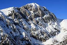
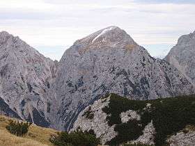
Brana
Brana (2,253 m) is a ridge mountain of the Kamnik Alps in northern Slovenia. It is located between the Logar Valley to the north and the Kamnik Bistrica Valley to the south. The mountain is part of the central Kamnik group, a long ridge that includes the highest peaks of the range such as Grintovec, Kočna, and Skuta. Brana is sometimes climbed as part of a long traverse of the entire Kamnik ridge.[1]
Starting points
Routes
- 2½ hrs from the Frischauf Lodge at Okrešelj at 1,378 m
- 1 hr from the Kamnik Saddle Lodge at 1,864 m
References
- ↑ "Brana - summitpost". summitpost.org. Retrieved 17 February 2015.
External links

- Brana on hribi.net Route Description and Photos (slo)
- Brana na Summitpost
This article is issued from
Wikipedia.
The text is licensed under Creative Commons - Attribution - Sharealike.
Additional terms may apply for the media files.