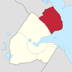
Obock Region
| Obock Region Rakaakay Obock Gobolka Obock إقليم أوبوك | |
|---|---|
| Region (Gobolka - Rakaakay) | |
 | |
 | |
| Coordinates: 11°58′N 43°18′E / 11.967°N 43.300°ECoordinates: 11°58′N 43°18′E / 11.967°N 43.300°E | |
| Country |
|
| Administrative centre | Obock |
| Area | |
| • Total | 4,700 km2 (1,800 sq mi) |
| Population (2009) | |
| • Total | 37,856 |
| • Density | 8.1/km2 (21/sq mi) |
| ISO 3166 code | DJ-OB |
The Obock Region (Afar: Rakaakay Obock, Arabic: إقليم أوبوك, Somali: Gobolka Obock) is a region in northern Djibouti. It has a land area of 4,700 square kilometres (1,800 sq mi), and had a population of 37,856 in 2009.[1]
History
In the mid-19th century and earlier, Obock was ruled by Somali and Afar Sultans, local authorities with whom France signed various treaties between 1883 and 1887 to first gain a foothold in the region.[2][3][4] The French developed Obock as a colonial port, while the Italians maintained a port to the north of Obock at Assab.[5]
Obock region became a separate administrative entity in 1927, with Michel Azenor appointed as chief.[6]
Geography
The region covers an area of 4,700 square kilometres (1,800 sq mi).[1] It is bordered by Eritrea to the north, the Tadjourah Region to the southwest, and the Red Sea and Gulf of Aden to the east.[7] There are several salt-lakes on the road to Tadjoura.[8]
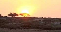
The regional capital is Obock which is positioned on the Gulf of Tadjoura littoral, by the sea, by a group of beaches and flattened abraded in coral beds with a very salty sheet of water. The wooded area of the Mabla Mountains, reaching more than 1,000 m and housing the second forest of the country, constitutes the natural border between the region of Obock and that of Tadjourah. The coastline is more than a thousand kilometers long. Obock with its proximity to Yemen (less than two hours).[7] The city has a functional airstrip and offers regular ferry services to Djibouti City.[9] Other notable towns include Daddato, Khor Angar, Andali, Bissidiro, Moulhoule, Alaili Dadda`, Waddi, Lahassa, Egahlou and Ribta.[7]
Economy
The region is characterized mainly by an activity oriented towards animal production (goat and dromedary farming), and agricultural activities in irrigated areas and artisanal fishing along the entire length of its coastline. The practice of small business and other informal activities is also widespread in the town of Obock and in the main localities. The number of salaried jobs is quite limited. The 200 fishermen of Obock are relatively well organized as part of their Association of Fishermen Cooperatives of Obock.

Climate
The Region is characterized by two seasons. The cool season which runs from November to April, and the warm season which begins in May and is often more or less dry. And the rare and low rainfall and endemic drought make this area one of the driest places in our country. The effects of climate change are also being felt. Sometimes it's hot and dry and sooner or later than usual. Sometimes it makes cool and wet longer or shorter, later or earlier than expected.
The annual mean statistics for some Tadjoura Region centres is shown below:
| Town | Min. Temp | Max. Temp | Rainfall |
|---|---|---|---|
| Khôr ‘Angar | 22.8 °C (73.0 °F) | 39.8 °C (103.6 °F) | 57 mm (2.2 in) |
| Obock | 22.3 °C (72.1 °F) | 41.0 °C (105.8 °F) | 80 mm (3.1 in) |
| Alaili Dadda` | 19.6 °C (67.3 °F) | 38.2 °C (100.8 °F) | 135 mm (5.3 in) |
| Medeho | 14.3 °C (57.7 °F) | 35.1 °C (95.2 °F) | 322 mm (12.7 in) |
References
- 1 2 Britannica Book of the Year 2012. Encyclopædia Britannica, Inc. 1 March 2012. p. 586. ISBN 978-1-61535-618-8.
- ↑ Raph Uwechue, Africa year book and who's who, (Africa Journal Ltd.: 1977), p.209.
- ↑ Hugh Chisholm (ed.), The encyclopædia britannica: a dictionary of arts, sciences, literature and general information, Volume 25, (At the University press: 1911), p.383.
- ↑ A Political Chronology of Africa, (Taylor & Francis), p.132.
- ↑ Ash, John; Atkins, John (30 June 2010). Birds of Ethiopia and Eritrea: An Atlas of Distribution. Bloomsbury Publishing. p. 16. ISBN 978-1-4081-3308-8.
- ↑ Simon, Imbert-Vier (20 April 2011). Tracer des frontières à Djibouti, des territoires et des hommes au XIXe et XXe siècles (in French). KARTHALA Editions. p. 137. ISBN 978-2-8111-3361-0.
- 1 2 3 Google (6 November 2016). "Obock Region" (Map). Google Maps. Google. Retrieved 6 November 2016.
- ↑ Rimbaud, Arthur (18 December 2007). I Promise to Be Good: The Letters of Arthur Rimbaud. Random House Publishing Group. p. 252. ISBN 978-0-307-43125-7.
- ↑ Carillet, Jean-Bernard; Bewer, Tim (1 May 2013). Lonely Planet Ethiopia, Djibouti & Somaliland. Lonely Planet. p. 487. ISBN 978-1-74321-647-7.