Oberwolfach
| Oberwolfach | ||
|---|---|---|
| ||
 Oberwolfach Location of Oberwolfach within Ortenaukreis district 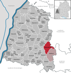  | ||
| Coordinates: 48°19′N 8°13′E / 48.317°N 8.217°ECoordinates: 48°19′N 8°13′E / 48.317°N 8.217°E | ||
| Country | Germany | |
| State | Baden-Württemberg | |
| Admin. region | Freiburg | |
| District | Ortenaukreis | |
| Government | ||
| • Mayor | Jürgen Nowak | |
| Area | ||
| • Total | 51.27 km2 (19.80 sq mi) | |
| Elevation | 323 m (1,060 ft) | |
| Population (2017-12-31)[1] | ||
| • Total | 2,602 | |
| • Density | 51/km2 (130/sq mi) | |
| Time zone | CET/CEST (UTC+1/+2) | |
| Postal codes | 77709 | |
| Dialling codes | 07834 | |
| Vehicle registration | OG | |
| Website | oberwolfach.de | |

Oberwolfach is a town in the district of Ortenau in Baden-Württemberg, Germany. It is the site of the Mathematical Research Institute of Oberwolfach, or Mathematisches Forschungsinstitut Oberwolfach.
Geography
Geographical situation
The town of Oberwolfach lies between 270 and 948 meters above sea level in the central Schwarzwald (Black Forest) on the river Wolf, a tributary of the Kinzig.
Neighbouring localities
The district is neighboured by Bad Peterstal-Griesbach to the north, Bad Rippoldsau-Schapbach in Landkreis Freudenstadt to the east, by the towns of Wolfach and Hausach to the south, and by Oberharmersbach to the west.
References
- ↑ "Bevölkerung nach Nationalität und Geschlecht am 31. Dezember 2017". Statistisches Landesamt Baden-Württemberg (in German). 2018.
External links
| Authority control |
|---|
This article is issued from
Wikipedia.
The text is licensed under Creative Commons - Attribution - Sharealike.
Additional terms may apply for the media files.