Lauf (Baden)
| Lauf | ||
|---|---|---|
 | ||
| ||
 Lauf Location of Lauf within Ortenaukreis district 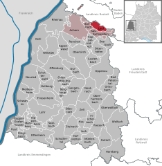  | ||
| Coordinates: 48°38′58″N 08°07′57″E / 48.64944°N 8.13250°ECoordinates: 48°38′58″N 08°07′57″E / 48.64944°N 8.13250°E | ||
| Country | Germany | |
| State | Baden-Württemberg | |
| Admin. region | Freiburg | |
| District | Ortenaukreis | |
| Government | ||
| • Mayor | Oliver Rastetter | |
| Area | ||
| • Total | 15.01 km2 (5.80 sq mi) | |
| Elevation | 279 m (915 ft) | |
| Population (2017-12-31)[1] | ||
| • Total | 3,956 | |
| • Density | 260/km2 (680/sq mi) | |
| Time zone | CET/CEST (UTC+1/+2) | |
| Postal codes | 77886 | |
| Dialling codes | 07841 | |
| Vehicle registration | OG | |
| Website | www.lauf-schwarzwald.de | |

Lauf is a community in the district of Ortenau in Western Baden-Württemberg, Germany.
Lauf is situated on the western edge of the Black Forest (Schwarzwald), located in a valley (Laufbachtal) that slopes roughly east-west. The Laufbach stream which gives Lauf its name rises on the north-west side of the Hornisgrinde, and descends rapidly past the Glashutte towards Lauf. In the Laufbachtal and side valleys, native vegetation flourishes, including orchids.
Vineyards are a major land-use, as the village has a good number of south-facing slopes. The local landscape consists of orchards, meadows and forest.
The population in July 2006 was 3,980 persons, compared to 900 in 1692.
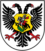
The Lauf coat of arms shows a red goblet on a silver background; emerging from both sides of the cup are clusters of grapes with leaves.
Places to eat in Lauf: Rebstock (Hauptstraße), Linde (Schlossstraße)
Bar in Lauf: Rabenkeller (Hauptstraße opposite the town hall).
Places to stay: Pension Hornenberg (Hornenbergstrasse) Gasthaus zur Linde (Schlossstrasse)
References
- ↑ "Bevölkerung nach Nationalität und Geschlecht am 31. Dezember 2017". Statistisches Landesamt Baden-Württemberg (in German). 2018.