Oberteuringen
| Oberteuringen | ||
|---|---|---|
| ||
 Oberteuringen Location of Oberteuringen within Bodenseekreis district 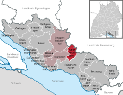  | ||
| Coordinates: 47°43′30″N 09°28′15″E / 47.72500°N 9.47083°ECoordinates: 47°43′30″N 09°28′15″E / 47.72500°N 9.47083°E | ||
| Country | Germany | |
| State | Baden-Württemberg | |
| Admin. region | Tübingen | |
| District | Bodenseekreis | |
| Government | ||
| • Mayor | Karl-Heinz Beck (CDU) | |
| Area | ||
| • Total | 20.06 km2 (7.75 sq mi) | |
| Elevation | 451 m (1,480 ft) | |
| Population (2017-12-31)[1] | ||
| • Total | 4,931 | |
| • Density | 250/km2 (640/sq mi) | |
| Time zone | CET/CEST (UTC+1/+2) | |
| Postal codes | 88094 | |
| Dialling codes | 07546 | |
| Vehicle registration | FN | |
| Website | www.oberteuringen.de | |

Oberteuringen is a town in the district of Bodensee in Baden-Württemberg in Germany.
It is located approximately 8 kilometers north of the Bodensee and south-east of the Gehrenberg mountain. The nearest cities are Markdorf, Friedrichshafen, Tettnang and Ravensburg.
The Oberteuringen council district comprises the villages Rammetshofen, Bitzenhofen, Hefigkofen, Neuhaus, Unterteuringen, Bibruck, Vittenhaag und Remette.
References
- ↑ "Bevölkerung nach Nationalität und Geschlecht am 31. Dezember 2017". Statistisches Landesamt Baden-Württemberg (in German). 2018.
Towns and municipalities in Bodensee (district) | ||
|---|---|---|
This article is issued from
Wikipedia.
The text is licensed under Creative Commons - Attribution - Sharealike.
Additional terms may apply for the media files.