Meckenbeuren
| Meckenbeuren | ||
|---|---|---|
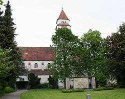 Church of St. Mary | ||
| ||
 Meckenbeuren Location of Meckenbeuren within Bodenseekreis district 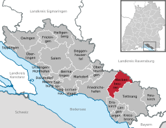  | ||
| Coordinates: 47°42′00″N 09°33′45″E / 47.70000°N 9.56250°ECoordinates: 47°42′00″N 09°33′45″E / 47.70000°N 9.56250°E | ||
| Country | Germany | |
| State | Baden-Württemberg | |
| Admin. region | Tübingen | |
| District | Bodenseekreis | |
| Government | ||
| • Mayor | Andreas Schmid | |
| Area | ||
| • Total | 31.90 km2 (12.32 sq mi) | |
| Elevation | 435 m (1,427 ft) | |
| Population (2017-12-31)[1] | ||
| • Total | 13,293 | |
| • Density | 420/km2 (1,100/sq mi) | |
| Time zone | CET/CEST (UTC+1/+2) | |
| Postal codes | 88074 | |
| Dialling codes | 07542 | |
| Vehicle registration | FN | |
| Website | www.meckenbeuren.de | |

Meckenbeuren is a municipality in the Bodensee district, in Baden-Württemberg, Southern Germany. It is located 10 kilometres (6 miles) south of Ravensburg, and 8 kilometres (5 miles) northeast of Friedrichshafen, on Lake Constance.
Geography
Location
Meckenbeuren is located about eight kilometres north of Friedrichshafen and ten kilometres south of Ravensburg in the lower Schussental valley near Lake Constance.
Districts
The municipality of Meckenbeuren includes, in addition to the core town of Obermeckenbeuren (since 1810), the former municipalities incorporated in 1937 and today's districts of Brochenzell and Liebenau (with the hamlets of Brugg, Hegenberg, Hirschach, Knellesberg, Langentrog, Schwarzenbach, Senglingen and Weiler, the farms of Berg, Buch, Furt, Hasenwinkel, Hohenreute, Holzbauer, Hungersberg, Kratzerach, Laufenen, Lohner, Madenreute, Mühlebach, Ottmarsreute, Rebholz, Regulator, Reuter, Sandgrub, Stengele, Straß, Untertennennenmoos and the houses Habacht) as well as the village of Kehlen, which was incorporated in 1972 (with the villages Kehlen and Reute, the hamlets of Buch, Gerbertshaus, Gunzenhaus, Holzreute, Lochbrücke, Sammletshofen, Sassen, Schürten, Schuppenwies, Sibratshaus and Siglishofen, the courtyards Großbuch, Hechelfurt and Schindelhof as well as the houses Schübelbeer).
Main sights
- Ravensburger Spieleland: a 25 hectare amusement park in the Liebenau district
- Humpismuseum (Humpis Museum) in the Humpisschloss (Humpis Castle) in the Brochenzell district
Gallery
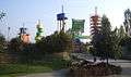 Ravensburger Spieleland (amusement park)
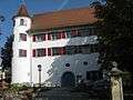 Humpisschloss in the Brochenzell district
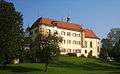 Schloss Liebenau (Liebenau Castle)
Twin cities


| Wikimedia Commons has media related to Meckenbeuren. |
References
- ↑ "Bevölkerung nach Nationalität und Geschlecht am 31. Dezember 2017". Statistisches Landesamt Baden-Württemberg (in German). 2018.
Towns and municipalities in Bodensee (district) | ||
|---|---|---|