Obernkirchen
| Obernkirchen | ||
|---|---|---|
| ||
 Obernkirchen Location of Obernkirchen within Schaumburg district 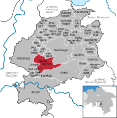  | ||
| Coordinates: 52°15′59″N 9°7′4″E / 52.26639°N 9.11778°ECoordinates: 52°15′59″N 9°7′4″E / 52.26639°N 9.11778°E | ||
| Country | Germany | |
| State | Lower Saxony | |
| District | Schaumburg | |
| Area | ||
| • Total | 32.55 km2 (12.57 sq mi) | |
| Elevation | 209 m (686 ft) | |
| Population (2017-12-31)[1] | ||
| • Total | 9,336 | |
| • Density | 290/km2 (740/sq mi) | |
| Time zone | CET/CEST (UTC+1/+2) | |
| Postal codes | 31683 | |
| Dialling codes | 0 57 24 | |
| Vehicle registration | SHG | |
| Website | www.obernkirchen.de | |
Obernkirchen (German pronunciation: [oːbɐnˈkɪʁçən]) is a town in the district of Schaumburg, in Lower Saxony, Germany. It is situated approximately 8 km southwest of Stadthagen, and 15 km east of Minden.
Obernkirchen is a small town in the shadows of the Bückeberg, a hill range in the Weser Uplands. It overlooks the vast lower lying part of the old county of Schaumburg Lippe, now the district of Schaumburg, with the town of Bückeburg at its feet.
References
External links
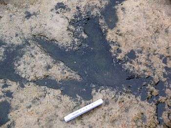
Dinosaur footprint from a trackway near Obernkirchen
| Authority control |
|---|
This article is issued from
Wikipedia.
The text is licensed under Creative Commons - Attribution - Sharealike.
Additional terms may apply for the media files.