Oberdachstetten
| Oberdachstetten | ||
|---|---|---|
| ||
 Oberdachstetten Location of Oberdachstetten within Ansbach district 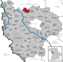 | ||
| Coordinates: 49°24.93′N 10°25.39′E / 49.41550°N 10.42317°ECoordinates: 49°24.93′N 10°25.39′E / 49.41550°N 10.42317°E | ||
| Country | Germany | |
| State | Bavaria | |
| Admin. region | Mittelfranken | |
| District | Ansbach | |
| Government | ||
| • Mayor | Martin Assum (CSU) | |
| Area | ||
| • Total | 23.66 km2 (9.14 sq mi) | |
| Elevation | 416-534 m (−1,336 ft) | |
| Population (2017-12-31)[1] | ||
| • Total | 1,626 | |
| • Density | 69/km2 (180/sq mi) | |
| Time zone | CET/CEST (UTC+1/+2) | |
| Postal codes | 91617 | |
| Dialling codes | 09845, 09829 (Berglein, Dörflein, Mitteldachstetten) | |
| Vehicle registration | AN, DKB, FEU, ROT | |
| Website | www.oberdachstetten.de | |

Oberdachstetten is a municipality in the district of Ansbach in Bavaria in Germany.
Gallery
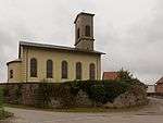 Oberdachstetten, reformed church: Pfarrkirche Sankt Bartholomäus
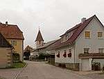 Mitteldachstetten, view to a street with churchtower
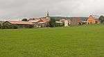 Berglein, vue to the village
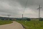 between Möckenau and Oberdachstetten, transmission towers in panorama
 between Kellern and Lehrberg, railway in panorama
References
- ↑ "Fortschreibung des Bevölkerungsstandes". Bayerisches Landesamt für Statistik und Datenverarbeitung (in German). September 2018.
This article is issued from
Wikipedia.
The text is licensed under Creative Commons - Attribution - Sharealike.
Additional terms may apply for the media files.