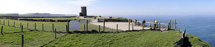
O'Brien's Tower
| O'Brien's Tower | |
|---|---|
| Túr Uí Bhriain | |
 O'Brien's Tower | |
 | |
| General information | |
| Status | in use |
| Type | Observation tower |
| Location | Cliffs of Moher, Clare |
| Town or city | Liscannor |
| Country | Ireland |
| Coordinates | 52°58′22.84″N 9°25′49.93″W / 52.9730111°N 9.4305361°WCoordinates: 52°58′22.84″N 9°25′49.93″W / 52.9730111°N 9.4305361°W |
| Elevation | 88 m (289 ft) |
| Named for | Cornelius O'Brien |
| Opened | 1835 |
| Client | Sir Cornelius O'Brien |
| Technical details | |
| Material | limestone |
| Floor count | 3 |
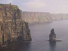
O'Brien's Tower marks the highest point of the Cliffs of Moher, a very popular tourist destination in County Clare, Ireland. It is located a short distance from the villages Doolin and Liscannor.
History
The tower was built on the cliffs in 1835 by local landlord and MP Sir Cornellius O'Brien as an observation tower for the Victorian tourists that frequented the cliffs at the time: "strangers visiting the Magnificent Scenery of this neighbourhood". It is said to have initially served as a teahouse, featuring a large round table with seats of ironwork.[1]:29
Another version tells of O'Brien building the tower in order to impress women he was courting. On a clear day the view can extend as far as Loop Head at the southern tip of Clare and beyond to the mountains of Kerry. Looking north from O'Brien's Tower on clear days, the Twelve Bens in Connemara (also known as the Twelve Pins) beyond Galway Bay can be seen, and typically the Aran Islands to the west.
References
- ↑ Roche, D. The Clare Guide - Official Irish Tourist Board Guide. Bord Failte.
- Portrait of Ireland: Landscapes, Treasures, Traditions (Dorling Kindersley Travel Guides), August 1, 2000, ISBN 0-7894-6361-X
External links
| Wikimedia Commons has media related to O'Brien's Tower. |