Liscannor
| Liscannor Lios Ceannúir | ||
|---|---|---|
| Village | ||
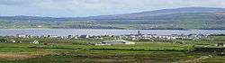 Panoramic View of Liscannor | ||
| ||
 Liscannor Location in Ireland | ||
| Coordinates: 52°56′19″N 9°23′38″W / 52.93851°N 9.394000°WCoordinates: 52°56′19″N 9°23′38″W / 52.93851°N 9.394000°W | ||
| Country | Ireland | |
| Province | Munster | |
| County | County Clare | |
| Elevation | 0 m (0 ft) | |
| Population (2006) | ||
| • Urban | 71 | |
| Time zone | UTC+0 (WET) | |
| • Summer (DST) | UTC-1 (IST (WEST)) | |
| Historical population | ||
|---|---|---|
| Year | Pop. | ±% |
| 1821 | 315 | — |
| 1831 | 506 | +60.6% |
| 1841 | 562 | +11.1% |
| 1851 | 429 | −23.7% |
| 1861 | 394 | −8.2% |
| 1871 | 415 | +5.3% |
| 1881 | 321 | −22.7% |
| 1891 | 286 | −10.9% |
| 1901 | 251 | −12.2% |
| 1911 | 242 | −3.6% |
| 1926 | 217 | −10.3% |
| 1936 | 183 | −15.7% |
| 1946 | 170 | −7.1% |
| 1951 | 146 | −14.1% |
| 1956 | 139 | −4.8% |
| 1961 | 106 | −23.7% |
| 1966 | 94 | −11.3% |
| 2002 | 108 | +14.9% |
| 2006 | 71 | −34.3% |
| [1] | ||
Liscannor (Irish: Lios Ceannúir, meaning "ringfort of Ceannúr"[2]) is a coastal village in County Clare, Ireland.
Geography
Lying on the west coast of Ireland, on Liscannor Bay, the village is located on the R478 road between Lahinch, to the east, and Doolin, to the north. The Cliffs of Moher are about 5 km (3.1 mi) north west of the village. Between Lahinch and Liscannor lies the small village of Moymore. Liscannor is located in the parish of Kilmacrehy.
Name
Liscannor probably takes its name from an old fort that was located here. Lis meaning a "fort" and Cannor a corruption of the name "Connor".[3]:66
Others say that it is derived from Lis, a "fort", cean a "head or headland" and or (uir) meaning "slaughter".
History

The area around Liscannor was part of the Barony of Corcomroe, controlled by the O’Connor family.
At least 30 ships of the Spanish Armada, sent to invade England in the summer of 1588, were lost along the coast of Ireland, mainly along the western seaboard. The oar-powered galleass Zuñiga anchored off-shore at Liscannor with a broken rudder. The ship came under surveillance by the High Sheriff of Clare and by crown forces and had to withdraw to their ship. One captive was taken and sent for interrogation. The Zuñiga escaped the coast with favorable winds, moored at Le Havre, and finally made it home to Naples in the following year.
The village of Liscannor is of late 18th century origin. According to an 1814 survey there were nearly 200 houses in it at the time, and about ten of them had flag roofs. 40 houses were used by fishermen.[3]:66
Attractions
Cliffs of Moher
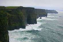
The Cliffs are one of Ireland's top visitor attractions and are one of the best examples of cliff-nesting seabird colonies in Ireland. The area was designated as a Refuge for Fauna in 1988 and as a Special Protection Area for Birds (SPA) under the EU Birds Directive in 1989. Included within the designated site are the cliffs, the cliff-top maritime grassland and heath, and a 200-metre zone of open water directly in front of the cliffs to protect part of the birds' feeding area. The designation covers 200 hectares and highlights the area's importance for wildlife.
Kilmacreehy Church and graveyard
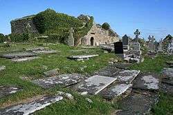
Cill MacCreiche (Kilmacreehy Church) is first documented in the 14th century, but most of the current Gothic ornamentation is later.
Liscannor Castle
This was an O'Connor stronghold, which like Dough Castle later passed to the O'Briens. In 1712, the Earl of Thomond let the estate to William Fitzgerald (annual rent ₤14). Under the Fitzgerald family, the town began to grow in the later 18th century.[3]:68
The ruined remains include a six-story tower with a spiral stairway to the east and a lower main building next to it. This latter was described in some detail by Thomas Johnson Westropp in the late 19th century, who noted that it had five floors.[3]:68–9
St. Brigid's Well
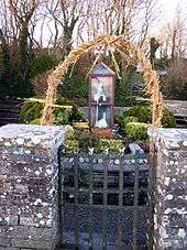
Located at a site of pre-Christian Lughnasadh celebrations,[3]:74 Dabhach Bhríde (or Brigid's Vat) is found near the Cliffs of Moher, and behind the well on a higher level, to which steps lead, is an ancient cemetery. There is a large cross here and a circular path around it, and part of the Rite of the Holy Well is performed in this area known as the Ula Uachtarach or upper sanctuary.
The well, dedicated to Brigid of Kildare, is in the lower ground, the Ula íochtarach or lower sanctuary, enclosed in a little house full of votive offerings such as holy pictures, rosaries, medals and so forth left by pilgrims. Small items which people carry around with them, such as pens, biros and combs, are commonly found also as offerings at wells.
The well has been the subject of a popular pilgrimage since at least the 1830s, when following a personal cure which he attributed to the waters of the well, Cornelius O'Brien had the well house built.[3]:74
Many pilgrims from all over County Clare and from the Aran Islands came to Liscannor. Pattern Days on which large groups attended included:
- St Brigid’s Day (1 February)
- Garland Saturday
- Garland Sunday[3]:74
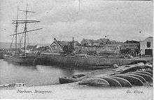
Liscannor Harbour
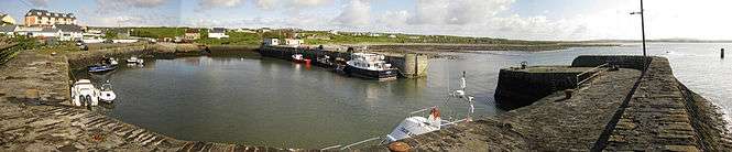
The harbour was built in 1825-31 for £2,900, of which £2,000 was a government grant. The harbour currently has a number of fishing vessels moored there as well as smaller boats using it is a launching site for sea fishing/recreational sports. During summer months there is also a ferry service to the base of the Cliffs of Moher as well as to the Aran Islands.
In the past the harbour was a hub for numerous fishing vessels as well as a location to export locally quarried Liscannor Stone and to receive in supplies e.g. coal. However historical documents note that due to the silting of the harbour, ships could only carry approximately 380 tonnes into port. At low tides ships had to be winched into harbour. A currach would bring the rope out to the ship. Locally quarried flag was cut and polished beside the harbour and winched onto ships by steam crane. These slabs were transported to various British cities (Glasgow, Manchester, etc.) for use as pavement slabs.
Coal was delivered directly to Liscannor up until the mid-1960s for Griffins coal yard in Ennistymon. However, in the mid-1960s a boat ran aground just outside the harbour and sank. The insurance became too expensive, and coal was then delivered to Ennistymon via Clarecastle.
Others
The engineer John Philip Holland (1841–1914) was born in Liscannor, and developed some of the first submarines commissioned by the US Navy and Royal Navy. A visitor centre, the "John P Holland Centre", was opened in Liscannor in 2016.
Holland is also honoured by a memorial donated by the Submarine Veterans of the US Navy.[3]:66
Churches
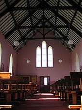
St. Brigid's Church
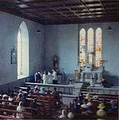
St Brigid's Church in Liscannor was built in 1858. It is a single-cell, four-bay church built of rubble masonry. A new roof was later added but the gallery, y-mullioned windows and semi-Tudor door were retained. Although the construction of a round tower was suggested in the 1920s, this Touheran tower which would have housed the bell as well as cottage industries on the lower floors was never built.[3]:68
Liscannor has been referred to as "the Pope's Own Parish". Located in the Diocese of Kilfenora, of which the Pope is the Bishop and the Bishop of Galway is the Apostolic Administrator, Liscannor is a mensal parish, i.e. directly under the direct authority of the bishop.[3]:68
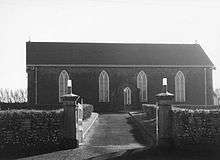
Moymore Church
The church of Moymore was built in 1877, on an elevated site overlooking the bay. There was no church previously at this location. Before that the people of the area attended Mass in a small thatched chapel a quarter mile to the east in Caheraderry (Derry).
Derry Church
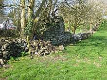
The Caheraderry (Derry) church probably dates from the 17th century penal times, built either to facilitate travelling friars or possibly as an out-chapel or hermitage for Kilmacreehy Church. It is possible that the church contained a small loft where the priest lived, as in Toomullin Church in Doolin. The ten perches of adjacent land belonging to the church would seem to indicate that there was a priest in residence who used this as a garden. Beside the ruins stand two small one-room attached cottages. According to local tradition, one of these cottages was a sheebeen known as Gleeson’s and the other a schoolhouse, where a hedge-schoolmaster taught.
Infrastructure
Transport
Bus Éireann route 350 links Liscannor to several locations: Ennis, Ennistymon, Cliffs of Moher, Doolin, Lisdoonvarna and Galway. There are a number of journeys each way daily. Onward rail and bus connections are available at Ennis and Galway.
Sports
Liscannor GAA
Liscannor won a county title in 1940 but this team was a combined team from the North Clare area. Liscannor GAA Club was reformed in 1985 as a separate entity after players from the area had played with The St Michaels team for a number of years. Liscannor were immediately successful and were promoted to Intermediate ranks after winning the Junior title in their first year after reforming in 1985. Liscannor also won the league title in 1985. An intermediate title followed in 1988 but the effects of emigration and a dwindling population meant that Liscannor were to revert to the Intermediate grade after one year at Senior level. Despite reaching a number of finals it would be 12 years later in 2000 before Liscannor returned to the Senior Grade.
Moher Celtic
Moher Celtic is the local football club. They have reached two Clare Cup finals in their history but have been edged out on both occasions.[4]
Local Folklore
Aill na Searrach: "Leap of the Foals"
Legend has it that when St. Patrick introduced Christianity to Ireland there was anger amongst the Tuatha Dé Danann. They decided to magically turn themselves into horses and galloped to Kilcornan, where they hid out in the Kilcornan Caves. As time went by there was no sign of the legendary Tuatha Dé Danann until one day seven foals emerged from the caves. They were frightened by the bright light of day and galloped along the edge of the Cliffs of Moher in fear. Legend says they galloped straight over the cliffs at the point known as Aill na Searrach (anglicised as Aillenasharragh), which is the Irish for "Leap of the Foals".
The Sunken City of Kilstipheen
Legend says that the ancient of city Kilstipheen (Cill Stíopháin, St. Stephen’s church) sank into the depths of Liscannor Bay due to a ghostly tsunami which occurred when the then chieftain lost a golden key in battle. This key was used to open the finest castle in the city. The city now cannot be restored to its former splendor until this lost key can be found. One legend has it that it is under an ogham gravestone on Mount Callan. Another legend says that the key was thrown into the depths of small lake on the same mountain and yet another that one day a fisherman will hook the golden key from the bottom of the ocean thus restoring the city to the surface. Folklore says that Kilstipheen, with its golden roofed palaces, ornate churches and spiraling towers can sometimes be seen shining below the surface of the waters as you look south to Miltown Malbay from Liscannor. It also says that once every seven years it rises above the surface of the waves but with if you spot the ancient city it is foretold that you will not survive the seven years until it surfaces again.
Mal the auld Hag
There once was an old hag named Mal who was adept in the dark arts of witchcraft. She fell in love with the legendary Cú Chulainn but her love was not returned. She chased him across the island of Ireland until they reached Loop Head in South Clare. Cú who had extraordinary strength and agility leapt from the Head onto the nearest island. Mal, using her magic, leapt after him so Cú jumped back to the mainland. Again Mal followed him but her jump fell short and she was dashed against the cliffs. Her blood reddened the water all the way from Loop Head to the Cliffs of Moher. Thus is how Malbay of Milltown Malbay got its name and her face can still be seen at Hags Head where the cliffs resemble an old hag looking out to sea.
St. McCreehy – the Demon Slayer of Liscannor
There is an old church and graveyard as you travel to Liscannor from Lahinch called Kilmacreehy (the church of McCreehy). The parish also takes its name from this saint. Legend has it that a monstrous eel burst forth from the depths of Liscannor Bay to feast on the corpses laid to rest at the graveyard. St McCreehy tackled this great beast and slew it after a long fight. A carving of the eel was present until recently at the old ruins.
So legendary was his bravery that St McCreehy was also needed to slay a demon dragon (called a bruckee). In fact the Bruckee was more than likely a bear but over time became exaggerated into a dragon. The Bruckee on ‘MacCreehy’s tomb’ in Kilmacreehy church, along the shore of Liscannor Bay has long pointed ears, large eyes and huge jaws blunt-ended, but bristling with vicious pointed teeth.
Notable people
- Cornelius O'Brien (1782-1857) Member of Parliament
- John Philip Holland (1840-1914) inventor of the modern submarine
See also
References
- ↑ http://www.cso.ie/census and www.histpop.org. Not listed as a separate census town between 1971 and 1996, For a discussion on the accuracy of pre-famine census returns see JJ Lee “On the accuracy of the pre-famine Irish censuses” in Irish Population, Economy and Society edited by JM Goldstrom and LA Clarkson (1981) p54, and also “New Developments in Irish Population History, 1700–1850” by Joel Mokyr and Cormac Ó Gráda in The Economic History Review, New Series, Vol. 37, No. 4 (Nov., 1984), pp. 473–488.
- ↑ A. D. Mills, 2003, A Dictionary of British Place-Names, Oxford University Press
- 1 2 3 4 5 6 7 8 9 10 Cunningham, George (1980). Burren Journey West. Shannonside Mid Western Regional Tourism Organisation. ISBN 0-9503080-2-1.
- ↑ "Archived copy". Archived from the original on 2013-09-30. Retrieved 2014-04-16.
External links
| Wikimedia Commons has media related to Liscannor. |
- Liscannor History - at Clare Library
- Comment on the harbour in 1901
Places in County Clare | ||
|---|---|---|
| Towns |  | |
| Villages |
| |
| Regions | ||
| Islands | ||
| ||