Nyngan
| Nyngan New South Wales | |||||||||
|---|---|---|---|---|---|---|---|---|---|
 Court house, Nyngan | |||||||||
|
Nyngan | |||||||||
| Coordinates | 31°34′0″S 147°12′0″E / 31.56667°S 147.20000°ECoordinates: 31°34′0″S 147°12′0″E / 31.56667°S 147.20000°E | ||||||||
| Population | 2,073 (2011 census)[1] | ||||||||
| Postcode(s) | 2825 | ||||||||
| Elevation | 173 m (568 ft) | ||||||||
| Location | |||||||||
| LGA(s) | Bogan Shire | ||||||||
| County | Oxley | ||||||||
| State electorate(s) | Barwon | ||||||||
| Federal Division(s) | Parkes | ||||||||
| |||||||||
Nyngan [pr: ning-gan] is a town in the centre of New South Wales, Australia, in the Bogan Shire local government area within the Orana Region of central New South Wales. At the 2011 census, Nyngan had a population of 2,073 people.[1] Nyngan is situated on the Bogan River between Narromine and Bourke, on the junction of the Mitchell Highway and Barrier Highway, 583 km north-west of Sydney by road. The Barrier Highway starts at Nyngan, and runs west to Cobar and on through Wilcannia and Broken Hill into South Australia.
Nyngan Airport is a small airport just north of the town centre. Nyngan also lies on the Main Western railway line of New South Wales but is no longer served by passenger trains. The line remains open to freight traffic.
About 70 kilometres south of the town a cairn was erected in 1988 marking the centre of NSW.[2]
History
The district was originally inhabited by the Wangaibon Aborigines. Thomas Mitchell explored the Bogan River in 1835, camping on the future townsite. He recorded the local Aboriginal word nyingan, said to mean 'long pond of water', though other meanings have been put forward, such as mussel or crayfish.[3] Squatters had settled in Mitchell's wake before he had begun his return journey.[4] The town flourished after completion of the railway line in 1883.
The little town of Canonbar, 25 kilometres to the north-east on Duck Creek, is part of the history of Nyngan. From the early 1840s until the middle 'eighties, it grew and flourished, servicing Canonbar Station and other properties, and Cobb and Co. travellers. In the early 1880s there were about four hotels, three or four banks, various stores and tradesmen, a police station, a telegraph and money-order office, and representatives of churches. The Western Railway by-passed Canonbar, and where it crossed the Bogan was Nyngan. The Canonbar populace, goods and public institutions then all moved to Nyngan. By 1890 it was practically empty.[5]
The Municipality of Nyngan was proclaimed on 17 February 1891 with Nyngan having a population of 1355.
The 1990 Nyngan flood
In April 1990, unusually heavy rains caused major flooding in the town, despite a massive effort by local people to raise the levee walls using sandbags. With the town almost completely flooded, all the residents had to be evacuated by helicopter from the railway station, the highest point of the town, which was not flooded. Air Force helicopters, TV news helicopters and private helicopters all co-operated in the airlift. The total damage amounted to $50 million. The airlift is commemorated by an Army helicopter placed outside of the Nyngan Railway Station. The railway station now houses a museum which includes exhibits relating to the 1990 flood. (The station had not been regularly used for train passengers since about 1980; the railway line to Bourke has been out of use since 17 May 1989 but the Cobar line remains open to carry ore and wheat.[6][7][8]
Heritage listings
Nyngan has a number of heritage-listed sites, including:
- Cemetery Road: Chinese Graves and Burner at Nyngan Cemetery[9]
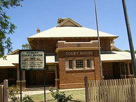
- 77-79 Cobar Street: Nyngan Court House[10]
Solar power
Approximately 10 kilometres (6.2 mi) west of the town is one of Australia's largest photovoltaic power station, with 1.36 million solar panels. It was the largest solar PV plant in Australia when launched in July 2016.[11][12] It complements another plant at Broken Hill, which was expected to be fully operational by the end of 2015, for a combined capacity of 155 megawatts (208,000 hp).[11]
Gallery
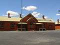 Railway station (now museum), Nyngan
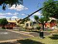 Helicopter commemorating the airlift during the 1990 floods
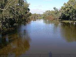 The Bogan River at Nyngan
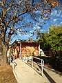 Bogan Shire Library, 73 Cobar Street Nyngan, New South Wales
References
- 1 2 Australian Bureau of Statistics (31 October 2012). "Nyngan (Urban Centre/Locality)". 2011 Census QuickStats. Retrieved 11 April 2014.

- ↑ Centre of New South Wales Cairn, Monument Australia retrieved 11 June 2012
- ↑ "Nyngan". Geographical Names Register (GNR) of NSW. Geographical Names Board of New South Wales. Retrieved 9 November 2009.
- ↑ "Nyngan - Culture and History". The Sydney Morning Herald. 17 November 2008.
- ↑ http://archiver.rootsweb.ancestry.com/th/read/AUS-NSW-WEST/2004-10/1097661802
- ↑ http://www.nswrail.net/lines/show.php?name=NSW:main_west
- ↑ http://www.nswrail.net/lines/show.php?name=NSW:cobar
- ↑ Bogan Shire Council: About: The Floods of April 1990
- ↑ "Chinese Graves and Burner at Nyngan Cemetery, New South Wales State Heritage Register (NSW SHR) Number H01783". New South Wales State Heritage Register. Office of Environment and Heritage. Retrieved 18 May 2018.
- ↑ "Nyngan Court House, New South Wales State Heritage Register (NSW SHR) Number H00797". New South Wales State Heritage Register. Office of Environment and Heritage. Retrieved 18 May 2018.
- 1 2 John Conroy (17 April 2015), "Panel perfect: Australia's largest solar plant complete", Business Spectator, retrieved 17 April 2015
- ↑ Nyngan Solar Plant Project Fact Sheet (PDF), AGL Energy Limited, retrieved 17 April 2015
External links
![]()
| Preceding station | NSW Main lines | Following station | ||
|---|---|---|---|---|
towards Bourke | Main Western Line | towards Sydney |
||
| Preceding station | NSW Branch lines | Following station | ||
Tikkara towards Cobar | Cobar Line | Terminus |