Numeira

Numeira is an archaeological site in Jordan near the southern Dead Sea.[1] The site has substantial Early Bronze Age remains.[2]
The site is 280m below Sea Level, on the shore of the Dead Sea.[3]
Numeira is also the name given to the river and valley (wadi) adjacent to the archaeological site. The river is significantly eroding the archaeological site, destroying perhaps as much as ½ the original settlement due to changes in the water course.[4]
Identification
It has been argued that Numeira approximates the alleged biblical city of Gomorrah, although other archaeologists argue that it is in the wrong geographical area, was a village as opposed to a major city, and is not within the designated timeframe.
Archaeology
Numeira was occupied during the EB III, and several indications that it was a colony of Bab edh-Dhra including a lack tombs yet been discovered in the vicinity of Numeira, and ceramic evidence the inhabitants buried their dead outside Bab edh-Dhra, approximately 13 km south of Bab edh-Dhra’.[5] If not a direct colony the pottery remains indicate the two towns certainly traded with each other.[6]
Calibrated radiocarbon dates place the settlement in the EB III. Habitation spanning approximately 250 years or 10-12 generations. Numeira was violently destroyed at the end of the EB III, (2300 BC.) never to be re-occupied.[7][8] This is 200 years earlier than the current assumed date for the destruction of Sodom.[9]
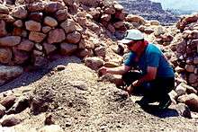
Excavations indicate Numeira was a 0.5 hectare walled settlement, though it may have been twice the size we see today.[10] Though only 30% of the site was excavated (c.1500 sq. meters) between 1979 -1983.[11] The settlement was located on the southern bank of the Wadi Numeira.[12]
Phase 1a saw the construction of several banks of lined pits around unused square areas. It is conjectured that this represented storage pits around a family tent.[13] In stage 1b saw the addition of more pits and walls, hearths, and evidence of a more seditary lifestyle. Phase 2 saw construction of fortification walls and residential and non-residential stone and mudbrick architecture. A non domestic area was located at the western gate.[14] The Phase 2 occupation saw the addition of more walls and storage pits. The final stage of occupation seems to have been a much smaller town and this ended when the town was burned.[15] and one of the fortification towers collapsed.[16] An interesting note is that many of the doors in the town at this time appear to have been blocked up.[17]
See also
- Bab edh-Dhra — a candidate site for "Sodom"
References
- ↑ Numeira: Jordan at the National Geospatial-Intelligence Agency, Bethesda, MD, USA].
- ↑ Numeira at Bible Places.com.
- ↑ James W. Flanagan, David M. Gunn, Paula McNutt, 'Imagining' Biblical Worlds(A&C Black, 2003)p252.
- ↑ James W. Flanagan, David M. Gunn, Paula McNutt, 'Imagining' Biblical Worlds(A&C Black, 2003)p252.
- ↑ NUMAYRA | Expedition Dead Sea Plain.
- ↑ Ianir Milevski, Early Bronze Age Goods Exchange in the Southern Levant: A Marxist Perspective (Routledge, 17 Sep. 2016).
- ↑ Numeira at Bible Places.com.
- ↑ James W. Flanagan, David M. Gunn, Paula McNutt, 'Imagining' Biblical Worlds(A&C Black, 2003)p252.
- ↑ Udd, Kris J., "Bab edh-Dhra', Numeira, and the Biblical Patriarchs: a Chronological Study" (2011). Dissertations. 157.
- ↑ NUMAYRA | Expedition Dead Sea Plain.
- ↑ NUMAYRA | Expedition Dead Sea Plain.
- ↑ Numeira at Bible Places.com.
- ↑ NUMAYRA | Expedition Dead Sea Plain.
- ↑ NUMAYRA | Expedition Dead Sea Plain.
- ↑ Numeira at Bible Places.com.
- ↑ NUMAYRA | Expedition Dead Sea Plain.
- ↑ James W. Flanagan, David M. Gunn, Paula McNutt, 'Imagining' Biblical Worlds(A&C Black, 2003)p252.
Coordinates: 31°07′54″N 35°31′46″E / 31.131588°N 35.529399°E