Null Island
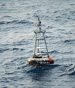 The weather buoy moored at the coordinates of Null Island | |
 Null Island Where the prime meridian and equator intersect in the Gulf of Guinea | |
| Geography | |
|---|---|
| Coordinates | 0°N 0°E / 0°N 0°ECoordinates: 0°N 0°E / 0°N 0°E |
Null Island is a name for the area around the point where the prime meridian and the equator cross; in the WGS84 datum, this is at zero degrees latitude and longitude [0°N 0°E / 0°N 0°E.[1]] (the location is in the Gulf of Guinea off the west African coast). The name 'Null Island' serves as both a joke based around the suppositional existence of an island there (in reality, only a buoy [pictured] exists there), and also as a name to which coordinates erroneously set to 0,0 are assigned in placenames databases in order to more easily find and fix them. The nearest land is Annobón island, at 1°25′S 5°38′E / 1.417°S 5.633°E.
Natural Earth
In the latter capacity it was added to the Natural Earth public domain map dataset[2][3][4] circa 2010-2011, after which the term came into wide use (although there is evidence of it being used previously[5]); since then, the 'island' has through fiction been given a geography (based on the setting of the video game Myst), history, and flag.[6] Natural Earth describes the entity as a "1 meter square island" with "scale rank 100, indicating it should never be shown in mapping."[2] The name 'Null' refers to the two 0 co-ordinates, both of which are sometimes known as null in mathematics.
The location is used by mapping systems to trap errors.[3] Such errors arise, for example, where an image artifact is erroneously associated to the location by software which cannot attribute a geo-position, and instead associates a latitude and longitude of "Null,Null" or "0,0".[7]
Other data mapped to the location include activity events from the Strava fitness-tracking app, apparently (as reported in January 2018 by Bellingcat) mapped to the location due to users entering "0,0" coordinates to disguise their real location.[8]
'Soul' Buoy
The only actual non-oceanic feature in that region is a moored weather and sea observation buoy, part of the PIRATA system operated jointly by the United States, France, and Brazil.[9] The depth at this place is around 4,940 metres (16,210 ft).[10]
See also
- Colonel Bleep, a 1957 cartoon that took place on the fictitious Zero Zero Island, at the same location as Null Island, where earth's equator meets the Greenwich Meridian.
References
- ↑ "Null Island". Archived from the original on 1 October 2013. Retrieved 1 October 2013.
- 1 2 Kurgan, Laura (2013). Close Up at a Distance: Mapping, Technology and Politics. New York: Zone Books. p. 157. ISBN 9781935408284.
- 1 2 "Natural Earth version 1.3 release notes". 2011-01-31. Archived from the original on 4 October 2013. Retrieved 1 October 2013.
- ↑ Hotz, Robert Lee (14 July 2016). "If You Can't Follow Directions, You'll End Up on Null Island". Wall Street Journal. Archived from the original on 13 July 2016. Retrieved 14 July 2016.
- ↑ "We call that spot "Null Island"". 2009-04-17. Archived from the original on 2018-09-10. Retrieved 2018-09-10.
- ↑ St. Onge, Tim. "The Geographical Oddity of Null Island". Library of Congress. Archived from the original on 12 May 2016. Retrieved 13 May 2016.
- ↑ "Null Island is One of the Most Visited Places on Earth. Too Bad It Doesn't Exist". Archived from the original on 25 August 2017. Retrieved 25 August 2017.
- ↑ Aric, Toler (29 January 2018). "How to Use and Interpret Data from Strava's Activity Map - bellingcat". Bellingcat. Retrieved 2 February 2018.
- ↑ "Station 13010 - Soul". National Data Buoy Center. Archived from the original on 22 August 2014. Retrieved 19 August 2014.
- ↑ "Bathymetric Data Viewer". National Geophysical Data Center (NGDC). National Oceanic and Atmospheric Administration. Archived from the original on 9 July 2017. Retrieved 2 July 2017.