Nuʻuanu Slide
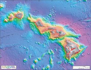
Nuʻuanu Slide or Nuʻuanu Debris Avalanche is the largest of seventeen submarine landslides around the Hawaiian Islands and at 200 km in length, one of the largest landslides on Earth. It broke from the eastern or windward side of Oahu, Hawaii between 1 to 1.5 million years ago and lies in the Pacific Ocean north of Molokai.[1][2]
At the time of collapse, Oahu was part of the conglomerate island Maui Nui, elevated above the ocean from lower sea levels, and contained the Koʻolau Volcano. The eastern half of the mountain collapsed nearly in half at the caldera. The remains of the eastern half of the caldera is now Kāneʻohe Bay and the new western side is the Koʻolau Range above the bay, including observation point Nuʻuanu Pali. Though the remaining ridge appears to be a steep and weathered fault scarp evidence suggests the geographic features are from wind and water rather than the landslide event.[2]
The volcano collapsed nearly in half at the caldera with the eastern half falling into the ocean cataclysmically with enough force to send debris including the massive Tuscaloosa seamount across the ocean floor and up a ridge.[2]
References
- ↑ http://geopubs.wr.usgs.gov/i-map/i2809/ Bathymetry image of the Hawaiian archipelago
- 1 2 3 Dunn, Patrick D. (2009). Vanished Islands and Hidden Continents of the Pacific. University of Hawai'i Press. pp. 44–46. ISBN 978-0-8248-3219-3 – via Project MUSE. (Subscription required (help)).