Novomyrhorod
| Novomyrhorod Новомиргород | |||
|---|---|---|---|
| Town | |||
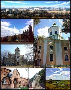 Clockwise from top right: Skyline of the town, Elias Church (1786), Panski Hory Reserve, Monument to Taras Shevchenko, Former Hospital (1913), Zlatopil Gymnasium, Central Square | |||
| |||
 Novomyrhorod  Novomyrhorod | |||
| Coordinates: 48°47′N 31°39′E / 48.783°N 31.650°ECoordinates: 48°47′N 31°39′E / 48.783°N 31.650°E | |||
| Country |
| ||
| Oblast |
| ||
| Founded | 1740 | ||
| Area | |||
| • Total | 88.52 km2 (34.18 sq mi) | ||
| Population (2017) | |||
| • Total | 11,247 | ||
| • Density | 130/km2 (330/sq mi) | ||
| Postal code | 26000-26001 | ||
| Area code(s) | +380 5256 | ||
| Website |
novomirgorod | ||
Novomyrhorod (Ukrainian: Новомиргород) is a city in Kirovohrad Oblast (region) of central Ukraine, in the southern part of the Middle Dnieper area. It is the administrative center of Novomyrhorod Raion. Its population is approximately 11,247 (2017 est.)[1].
Novomyrhorod is situated on the banks of the Velyka Vys River.
Name and history
The name literally means "New Myrhorod" or "new peace town".
The first mention of the city dates from the 1740.
Between 1752 and 1764, Novomyrhorod was the capital of New Serbia.
Since 1923 Novomyrhorod was the district center of Yelysavethradsky District, Ukrainian SSR. From 1959, the town has a regional subordination.
Cabinet of Ministers of Ukraine of 26 July 2001, the town Novomyrhorod listed under Historic Settlements of Ukraine. In 2010, was its 270-year anniversary.
Gallery
 Location of Novomyrhorod and former New Serbia
 Novomyrhorod railway station
 Entering the Novomyrhorod from the Kropyvnytskyi's side
See also
References
- ↑ "Чисельність наявного населення України (Actual population of Ukraine)" (in Ukrainian). State Statistics Service of Ukraine. Retrieved 26 August 2017.
| Raions | |||||
|---|---|---|---|---|---|
| Cities |
| ||||
| |||||