Novobayazetsky Uyezd
| Novobayazetsky Uyezd (in English) | ||
|---|---|---|
| ||
 | ||
| ||
| Established | 1849 | |
| Abolished | 1918 | |
| Political status | Uyezd | |
| Region | Caucasus | |
| Area | 4,156.8 verst² | |
| Population (1897 census) | ||
| • Total | 122573 | |
| • Density | 29.5 inhab. / verst² | |
| Government | ||
.png)
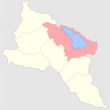
The Novobayazetsky Uyezd (Russian: Новобаязетский уезд; Armenian: Նոր Բայազետի գավառ) was a county of the Erivan Governorate of the Caucasus Viceroyalty of the Russian Empire. It bordered the governorate's Aleksandropolsky Uyezd to the north, the Echmiadzinsky and Erivansky Uyezds to the west, the Sharur-Daralagezsky Uyezd to the south, and the Kazakhsky, Yelizavetpolsky, and Dzhevanshirsky Uyezds of the Elisabethpol Governorate to the east. Centered on Lake Sevan, it included most of the Gegharkunik Province and northern parts of the Kotayk Province of present-day Armenia. Its administrative center was Novo-Bayazet (Gavar).[1]
Demographics
According to the 1897 Russian Empire Census, the population of the district was 122,573, the majority of which were Armenians (66.4%). Minorities included Tatars (modern Azerbaijanis; 28.5%), East Slavs (Russians, Ukrainians, and Belarusians; 2.2%), and Kurds (2.4%).[2] The largest city in the district was Novo-Bayazet, which had a total population of 8,486, of which the overwhelming majority (95%) were Armenians.[3]
References
- ↑ Tsutsiev, Arthur (2014). Atlas of the Ethno-Political History of the Caucasus. Translated by Nora Seligman Favorov. New Haven: Yale University Press. p. 59. ISBN 9780300153088.
- ↑ (in Russian) 1897 Census, Novobayazetsky Uyezd Demoscope Weekly
- ↑ (in Russian) 1897 Census, Novobayazet City Demoscope Weekly
Administrative divisions of the Erivan Governorate | ||
|---|---|---|
Italics indicates abolished uyezds. | ||