Nový Jičín
| Nový Jičín | |||
| Town | |||
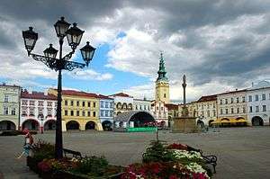 Masaryk Square | |||
|
|||
| Country | Czech Republic | ||
|---|---|---|---|
| Region | Moravian-Silesian | ||
| District | Nový Jičín | ||
| Commune | Nový Jičín | ||
| Elevation | 285 m (935 ft) | ||
| Coordinates | 49°35′N 18°00′E / 49.583°N 18.000°ECoordinates: 49°35′N 18°00′E / 49.583°N 18.000°E | ||
| Area | 44.71 km2 (17.26 sq mi) | ||
| Population | 27,617 (2007-07-01) | ||
| Density | 618/km2 (1,601/sq mi) | ||
| First mentioned | 1313 | ||
| Mayor | Jaroslav Dvořák | ||
| Timezone | CET (UTC+1) | ||
| - summer (DST) | CEST (UTC+2) | ||
| Postal code | 741 01 | ||
  Location in the Czech Republic | |||
 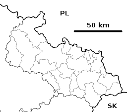 Location in the Moravian-Silesian Region | |||
| Wikimedia Commons: Nový Jičín | |||
| Statistics: statnisprava.cz | |||
| Website: www | |||


Nový Jičín (Czech pronunciation: [ˈnoviː ˈjɪtʃiːn]; German: Neutitschein) is a town in the Moravian-Silesian Region of the Czech Republic. It has appximately 26,500 inhabitants. The city is situated on the spurs of the Carpathian Mountains[1] about 30 km (19 mi) from the Czech Republic's 3rd biggest city, Ostrava. The city is noted for its hatting industry.
History
The town was founded in 1311.[1] Until 1918 the town was part of the Austrian monarchy (Austria side after the compromise of 1867), head of the district with the same name, one of the 34 Bezirkshauptmannschaften in Moravia.[2] The German population was expelled in 1945.
Twin towns - sister cities
Nový Jičín is twinned with:
References
- 1 2

- ↑ Die postalischen Abstempelungen auf den österreichischen Postwertzeichen-Ausgaben 1867, 1883 und 1890, Wilhelm KLEIN, 1967
External links
- Municipal website (in Czech)
- Further info
| Wikimedia Commons has media related to Nový Jičín. |
This article is issued from
Wikipedia.
The text is licensed under Creative Commons - Attribution - Sharealike.
Additional terms may apply for the media files.