Frenštát pod Radhoštěm
| Frenštát pod Radhoštěm | |||
| Town | |||
_-_town_hall.jpg) Town hall at the Peace Square | |||
|
|||
| Country | Czech Republic | ||
|---|---|---|---|
| Region | Moravian-Silesian | ||
| District | Nový Jičín | ||
| Commune | Frenštát pod Radhoštěm | ||
| Center | Náměstí Míru | ||
| - elevation | 401 m (1,316 ft) | ||
| - coordinates | 49°32′51″N 18°12′42″E / 49.54750°N 18.21167°ECoordinates: 49°32′51″N 18°12′42″E / 49.54750°N 18.21167°E | ||
| Area | 11.44 km2 (4.42 sq mi) | ||
| Population | 10,990 (2012) | ||
| Density | 961/km2 (2,489/sq mi) | ||
| First mentioned | 1382 | ||
| Mayor | Mgr. Zdeňka Leščišinová | ||
| Timezone | CET (UTC+1) | ||
| - summer (DST) | CEST (UTC+2) | ||
| Postal code | 744 01 | ||
  Location in the Czech Republic | |||
 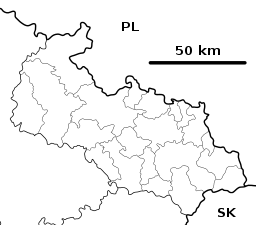 Location in the Moravian-Silesian Region | |||
| Wikimedia Commons: Frenštát pod Radhoštěm | |||
| Statistics: statnisprava.cz | |||
| Website: www.frenstat.info | |||


Frenštát pod Radhoštěm (Czech pronunciation: [ˈfrɛnʃtaːt ˈpod radɦoʃcɛm]; German: Frankstadt unter dem Radhoscht) is a town in the Moravian-Silesian Region of the Czech Republic.
It lies under the Moravian-Silesian Beskids Range, in a region rich in history and therefore the town is an important holiday resort in both summer and winter.
Twin towns — sister cities
Frenštát pod Radhoštěm is twinned with:


External links

This article is issued from
Wikipedia.
The text is licensed under Creative Commons - Attribution - Sharealike.
Additional terms may apply for the media files.