Norwegian Bay
| Norwegian Bay | |
|---|---|
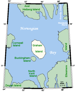 Norwegian Bay and some of its islands. | |
| Location | Arctic ocean |
| Coordinates | 77°29′59″N 90°29′59″W / 77.49972°N 90.49972°WCoordinates: 77°29′59″N 90°29′59″W / 77.49972°N 90.49972°W |
| Basin countries | Canada |
| Max. length | 161 km (100 mi)[1] |
| Max. width | 145 km (90 mi) |
| Settlements | Uninhabited |
Norwegian Bay (French: Baie Norvégienne) is an Arctic ocean waterway in Qikiqtaaluk Region. Nunavut, Canada. Amund Ringnes Island is to the northwest (separated by 10 km (6.2 mi) wide Hendriksen Strait from Cornwall Island), and Axel Heiberg Island to the north (both islands being part of the Sverdrup Islands), Ellesmere Island is to the east, and Devon Island is to the south. Six islands lie within Norwegian Bay:
- Cornwall Island (the largest and westernmost)
- Graham Island
- Buckingham
- Table
- Exmouth
- Ekins
References
- ↑ "Norwegian Bay". The Columbia Gazetteer of North America. 2000. Archived from the original on 2004-07-02. Retrieved 2008-06-04.
- Norwegian Bay at Atlas of Canada
This article is issued from
Wikipedia.
The text is licensed under Creative Commons - Attribution - Sharealike.
Additional terms may apply for the media files.