Northgate, North Dakota
| Northgate, North Dakota | |
|---|---|
| Unincorporated community | |
 Northgate, North Dakota  Northgate, North Dakota | |
| Coordinates: 48°59′27″N 102°15′44″W / 48.99083°N 102.26222°WCoordinates: 48°59′27″N 102°15′44″W / 48.99083°N 102.26222°W | |
| Country | United States |
| State | North Dakota |
| County | Burke |
| Elevation | 1,860 ft (570 m) |
| Time zone | UTC-6 (Central (CST)) |
| • Summer (DST) | UTC-5 (CDT) |
| ZIP code | 58737 |
| Area code(s) | 701 |
| GNIS feature ID | 1030491[1] |
Northgate is an unincorporated community in Burke County, North Dakota, United States. The community is adjacent to the U.S. border with Canada, and it shares its name with the neighboring Canadian settlement of Northgate, Saskatchewan. The community is served by North Dakota Highway 8.
The former Port of Entry building was razed in 2014/2015 for unknown reasons. Almost all of Northgate, Saskatchewan was razed in 2013/2014 to make room for an extension of the Canadian National Railway.
References
Municipalities and communities of Burke County, North Dakota, United States | ||
|---|---|---|
| Cities | 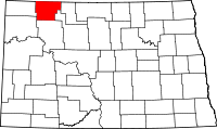 | |
| Townships |
| |
| CDP | ||
| Unorganized territory |
| |
| Unincorporated communities |
| |
| Indian reservation | ||
| Footnotes | ‡This populated place also has portions in an adjacent county or counties | |
This article is issued from
Wikipedia.
The text is licensed under Creative Commons - Attribution - Sharealike.
Additional terms may apply for the media files.