Northern Bruce Peninsula
| Northern Bruce Peninsula | |
|---|---|
| Municipality (lower-tier) | |
| Municipality of Northern Bruce Peninsula | |
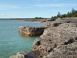 Pike Bay | |
 Northern Bruce Peninsula Location in southern Ontario | |
| Coordinates: 45°05′N 81°23′W / 45.08°N 81.38°WCoordinates: 45°05′N 81°23′W / 45.08°N 81.38°W | |
| Country |
|
| Province |
|
| County | Bruce |
| Formed | January 1, 1999 |
| Government | |
| • Mayor | Milt McIver |
| • Federal riding | Bruce—Grey—Owen Sound |
| • Prov. riding | Bruce—Grey—Owen Sound |
| Area[1] | |
| • Land | 783.99 km2 (302.70 sq mi) |
| Population (2016)[1] | |
| • Total | 3,999 |
| • Density | 5.1/km2 (13/sq mi) |
| Time zone | UTC-5 (EST) |
| • Summer (DST) | UTC-4 (EDT) |
| Postal Code | N0H |
| Area code(s) | 519 and 226 |
| Website |
www |
The Municipality of Northern Bruce Peninsula is located on the Bruce Peninsula in Bruce County, Ontario, Canada. It is a popular vacation spot in the summer for its water sports and cottaging, and in the winter for snowmobiling. The popularity of the area has led to severe strain on the infrastructure and quality of life especially in the summer. Huge crowds of tourists and their vehicles overwhelm parking and facilities. The one highway into the area, Highway 6, is experiencing an increase in accidents and speeding vehicles. The municipality was formed on January 1, 1999, when the townships of St. Edmunds, Lindsay, and Eastnor (which was named after Eastnor, Herefordshire[2]), as well as the Village of Lion's Head, were amalgamated.
It is home to the Bruce Peninsula National Park, the Fathom Five National Marine Park, and the Lion's Head Provincial Park.
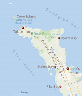 |
| Map of Northern Bruce Peninsula municipality.[3] |
Communities
Its main population centres are Lion's Head and Tobermory. Other communities include Barrow Bay, Clarke's Corners, Dyer's Bay, Ferndale, Hope Bay, Miller Lake, Pike Bay, and Stokes Bay.
Demographics
| Canada census – Northern Bruce Peninsula community profile | |||
|---|---|---|---|
| 2016 | 2011 | ||
| Population: | 3999 (6.8% from 2011) | 3744 (−2.8% from 2006) | |
| Land area: | 783.99 km2 (302.70 sq mi) | 781.77 km2 (301.84 sq mi) | |
| Population density: | 5.1/km2 (13/sq mi) | 4.8/km2 (12/sq mi) | |
| Median age: | 60.4 (M: 60.1, F: 60.6) | 57.3 (M: 57.1, F: 57.5) | |
| Total private dwellings: | 5069 | 4954 | |
| Median household income: | $39,787 | ||
| References: 2016[4] 2011[5] earlier[6] | |||
Population trend:[7]
- Population in 2011: 3744
- Population in 2006: 3850
- Population in 2001: 3599
- Population total in 1996: 3500
- Eastnor (township): 1443
- Lindsay (township): 500
- Lion's Head (village): 550
- St. Edmunds (township): 1007
See also
References
- 1 2 "Census Profile, 2016 Census, Northern Bruce Peninsula, Municipality [Census subdivision]".
- ↑ Hepburn, Glen Gordon (1987). Benchmarks : A History of Eastnor Township and Lion's Head. Owen Sound: The Eastnor and Lion's Head Historical Society. p. 13. ISBN 0-9692848-0-2.
- ↑ "Bruce Peninsula National Park: Parks map". Parks Canada. Retrieved June 21, 2018.
- ↑ "2016 Community Profiles". Canada 2016 Census. Statistics Canada. February 21, 2017. Retrieved 2017-11-06.
- ↑ "2011 Community Profiles". Canada 2011 Census. Statistics Canada. July 5, 2013. Retrieved 2012-03-16.
- ↑ "2001 Community Profiles". Canada 2001 Census. Statistics Canada. February 17, 2012.
- ↑ Statistics Canada: 1996, 2001, 2006 census
External links

Places adjacent to Northern Bruce Peninsula | |
|---|---|