North Thompson River
| North Thompson River | |
.jpg) North Thompson River near Vavenby | |
| Name origin: The Thompson River was named by Simon Fraser in honour of David Thompson [1] | |
| Country | Canada |
|---|---|
| Province | British Columbia |
| Source | Thompson Glacier |
| - location | Premier Range, Cariboo Mountains |
| - elevation | 1,675 m (5,495 ft) [2] |
| - coordinates | 52°40′56″N 119°40′25″W / 52.68222°N 119.67361°W [3] |
| Mouth | Thompson River |
| - location | Kamloops |
| - elevation | 339 m (1,112 ft) [2] |
| - coordinates | 50°40′55″N 120°20′28″W / 50.68194°N 120.34111°WCoordinates: 50°40′55″N 120°20′28″W / 50.68194°N 120.34111°W [4] |
| Discharge | for McLure Ferry |
| - average | 427 m3/s (15,079 cu ft/s) [5] |
| - max | 2,740 m3/s (96,762 cu ft/s) |
| - min | 39.2 m3/s (1,384 cu ft/s) |
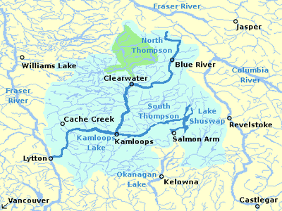 Thompson River's watershed | |
The North Thompson River is the northern branch of the Thompson River, the largest tributary of the Fraser River, in the Canadian province of British Columbia. It originates at the toe of the Thompson Glacier[3] in the Premier Range of the Cariboo Mountains, west of the community of Valemount. The river flows generally south through the Shuswap Highland towards Kamloops where it joins the South Thompson River to form the main stem Thompson River.
For most of its length, the river is paralleled by Highway 5, and the Canadian National Railway (both of which cross the river a couple of times). The North Thompson passes by several small communities, the most notable being Blue River, Clearwater, and Barriere.
Tributaries of the North Thompson River including the Albreda River,[6] Thunder River,[7] Mud Creek,[8] Blue River,[9] Mad River,[10] Raft River,[11] Clearwater River,[12] and Barrière River.[13]
The North Thompson's largest tributary is the Clearwater River, which joins at the town of Clearwater. The Clearwater River drains much of Wells Gray Provincial Park.
A notable feature along the North Thompson is Little Hells Gate, a mini-replica of the much larger Hells Gate rapids on the Fraser River. About 17.4 kilometres (10.8 mi) upstream from the small town of Avola, the North Thompson River is forced through a narrow chute only about 30 feet (9.1 m) wide, creating a rapid that resembles the Fraser's famous rapid. Many river rafting companies offer a variety of trips through the rapids.
See also
References
- ↑ "Thompson River". BC Geographical Names.
- 1 2 Elevation derived from ASTER Global Digital Elevation Model, using GeoLocator, and BCGNIS coordinates
- 1 2 "Thompson Glacier". BC Geographical Names.
- ↑ "North Thompson River". BC Geographical Names.
- ↑ "Archived Hydrometric Data Search". Water Survey of Canada. Archived from the original on 24 December 2010. Retrieved 22 August 2013. Search for Station 08LB064 North Thompson River at McLure
- ↑ "Albreda River". BC Geographical Names.
- ↑ "Thunder River". BC Geographical Names.
- ↑ "Mud Creek". BC Geographical Names.
- ↑ "Blue River". BC Geographical Names.
- ↑ "Mad River". BC Geographical Names.
- ↑ "Raft River". BC Geographical Names.
- ↑ "Clearwater River". BC Geographical Names.
- ↑ "Barrière River". BC Geographical Names.
External links
