North Padang Lawas Regency
| North Padang Lawas Regency (Kabupaten Padang Lawas Utara) | ||
|---|---|---|
| Regency | ||
| ||
 | ||
| Country | Indonesia | |
| Province | North Sumatra | |
| Capital | Gunung Tua | |
| Area | ||
| • Total | 3,918.05 km2 (1,512.77 sq mi) | |
| Population (2014 Estimate) | ||
| • Total | 232,928 | |
| • Density | 59/km2 (150/sq mi) | |
| Time zone | UTC+7 (WIB) | |
| Website |
www | |

North Padang Lawas (Padang Lawas Utara) is a regency in North Sumatra province of Indonesia. It has an area of 3,918.05 km2, and had a population of 223,049 at the 2010 Census;[1] the latest estimate (as at January 2014) is 232,928. Its administrative seat is Gunung Tua.
Administration
The regency is divided into nine districts (kecamatan), tabulated below with their 2010 Census population:[2]
| Name | Population Census 2010[2] |
|---|---|
| Batang Onang | 12,790 |
| Padang Bolak Julu | 9,972 |
| Portibi | 23,228 |
| Padang Bolak | 58,560 |
| Simangambat | 46,769 |
| Halongonan | 29,058 |
| Dolok | 22,573 |
| Dolok Sigompulon | 15,610 |
| Hulu Sihapas | 4,683 |
Archaeology
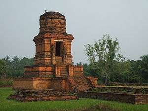
The Padang Lawas archaeological site is partly located in the regency. The site covers approximately 1,500 km², spreading the kecamatan (districts) of Portibi in the regency, Barumun and Barumun Tengah in the Padang Lawas Regency and Padangbolak in the South Tapanuli Regency. Hindu-Buddhist remains are found on the site, including structures called biaro (from Sanskrit vihara, meaning "temple" or "monastery").
References
- Simanjuntak, Truman, M. Hisyam, Bagyo Prasetyo, Titi Surti Nastiti (éds.), Archaeology: Indonesian perspective : R.P. Soejono's festschrift, LIPI, Jakarta, 2006, ISBN 979-26-2499-6